Osterhofen
Osterhofen | |
|---|---|
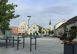 Market square | |
 Coat of arms | |
Location of Osterhofen within Deggendorf district 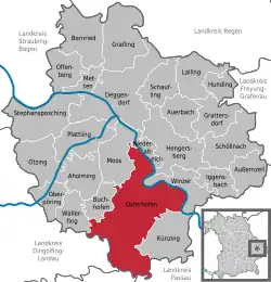 | |
 Osterhofen  Osterhofen | |
| Coordinates: 48°42′07″N 13°01′12″E / 48.70194°N 13.02000°E | |
| Country | Germany |
| State | Bavaria |
| Admin. region | Niederbayern |
| District | Deggendorf |
| Government | |
| • Mayor (2020–26) | Liane Sedlmeier[1] (FW) |
| Area | |
• Total | 111.17 km2 (42.92 sq mi) |
| Elevation | 318 m (1,043 ft) |
| Population (2024-12-31)[2] | |
• Total | 12,280 |
| • Density | 110/km2 (290/sq mi) |
| Time zone | UTC+01:00 (CET) |
| • Summer (DST) | UTC+02:00 (CEST) |
| Postal codes | 94486 |
| Dialling codes | 09932 |
| Vehicle registration | DEG |
| Website | www.osterhofen.de |
Osterhofen (German pronunciation: [oːstɐˈhoːfn̩] ⓘ) is a town in the district of Deggendorf, in Bavaria, Germany. It is situated on the right bank of the Danube, 16 km south of Deggendorf.
The town surrounds Osterhofen Abbey, a former monastery, whose abbey church is now the Basilica of St. Margaretha.[3]
References
- ^ Liste der ersten Bürgermeister/Oberbürgermeister in kreisangehörigen Gemeinden, Bayerisches Landesamt für Statistik, 15 July 2021.
- ^ "Gemeinden, Kreise und Regierungsbezirke in Bayern, Einwohnerzahlen am 31. Dezember 2024; Basis Zensus 2022" [Municipalities, counties, and administrative districts in Bavaria; Based on the 2022 Census] (CSV) (in German). Bayerisches Landesamt für Statistik.
- ^ "Sehenswürdigkeiten" (in German). Stadt Osterhofen. Archived from the original on 2014-01-04. Retrieved 2014-01-04.
Towns and municipalities in Deggendorf (district) | ||
|---|---|---|
 | ||