Příčina
Příčina | |
|---|---|
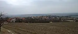 General view | |
.svg.png) Flag  Coat of arms | |
 Příčina Location in the Czech Republic | |
| Coordinates: 50°3′57″N 13°40′2″E / 50.06583°N 13.66722°E | |
| Country | |
| Region | Central Bohemian |
| District | Rakovník |
| First mentioned | 1357 |
| Area | |
• Total | 2.19 km2 (0.85 sq mi) |
| Elevation | 475 m (1,558 ft) |
| Population (2025-01-01)[1] | |
• Total | 208 |
| • Density | 95/km2 (250/sq mi) |
| Time zone | UTC+1 (CET) |
| • Summer (DST) | UTC+2 (CEST) |
| Postal code | 270 35 |
| Website | www |
Příčina is a municipality and village in Rakovník District in the Central Bohemian Region of the Czech Republic. It has about 200 inhabitants.
Demographics
| Year | Pop. | ±% |
|---|---|---|
| 1869 | 332 | — |
| 1880 | 558 | +68.1% |
| 1890 | 361 | −35.3% |
| 1900 | 317 | −12.2% |
| 1910 | 377 | +18.9% |
| 1921 | 416 | +10.3% |
| 1930 | 405 | −2.6% |
| 1950 | 307 | −24.2% |
| 1961 | 316 | +2.9% |
| 1970 | 285 | −9.8% |
| 1980 | 207 | −27.4% |
| 1991 | 187 | −9.7% |
| 2001 | 164 | −12.3% |
| 2011 | 180 | +9.8% |
| 2021 | 206 | +14.4% |
| Source: Censuses[2][3] | ||
References
- ^ "Population of Municipalities – 1 January 2025". Czech Statistical Office. 2025-05-16.
- ^ "Historický lexikon obcí České republiky 1869–2011" (in Czech). Czech Statistical Office. 2015-12-21.
- ^ "Population Census 2021: Population by sex". Public Database. Czech Statistical Office. 2021-03-27.
External links
Wikimedia Commons has media related to Příčina.