Pain Rokh Rural District
Pain Rokh Rural District
Persian: دهستان پائين رخ | |
|---|---|
 Pain Rokh Rural District | |
| Coordinates: 35°35′34″N 59°26′13″E / 35.59278°N 59.43694°E[1] | |
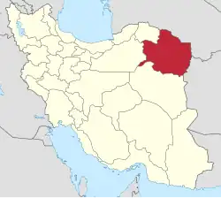
| Country | Iran |
| Province | Razavi Khorasan |
| County | Torbat-e Heydarieh |
| District | Jolgeh Rokh |
| Capital | Sar Bala |
| Population (2016)[2] | |
• Total | 10,686 |
| Time zone | UTC+3:30 (IRST) |
Pain Rokh Rural District (Persian: دهستان پائين رخ) is in Jolgeh Rokh District of Torbat-e Heydarieh County, Razavi Khorasan province, Iran.[3] Its capital is the village of Sar Bala.[4] The previous capital of the rural district was Nasar.[5]
Demographics
Population
At the time of the 2006 National Census, the rural district's population was 10,156 in 2,458 households.[6] There were 9,257 inhabitants in 2,590 households at the following census of 2011.[7] The 2016 census measured the population of the rural district as 10,686 in 3,141 households. The most populous of its 33 villages was Nasar (now a city),[4] with 3,633 people.[2]
See also
References
- ^ OpenStreetMap contributors (5 November 2024). "Pain Rokh Rural District (Torbat-e Heydarieh County)" (Map). OpenStreetMap (in Persian). Retrieved 5 November 2024.
- ^ a b Census of the Islamic Republic of Iran, 1395 (2016): Razavi Khorasan Province. amar.org.ir (Report) (in Persian). The Statistical Center of Iran. Archived from the original (Excel) on 2 April 2022. Retrieved 19 December 2022.
- ^ Habibi, Hassan (1 June 2017) [Approved 15 July 1375]. Reforms of national divisions in Khorasan province. rc.majlis.ir (Report) (in Persian). Ministry of the Interior, Political-Defense Commission of the Government Board. Proposal 1.4.42.7504; Notification 127903/T17245K. Archived from the original on 22 May 2018. Retrieved 4 January 2024 – via Islamic Parliament Research Center of the Islamic Republic of Iran.
- ^ a b Jahangiri, Ishaq (4 July 2021) [Approved 27 December 1399]. Approval regarding national divisions in Torbat-e Heydarieh County, Razavi Khorasan province. sdil.ac.ir (Report) (in Persian). Ministry of the Interior, Cabinet of Ministers. Proposal 118708; Notification 156670/T56973AH. Archived from the original on 26 March 2023. Retrieved 31 January 2025 – via Shahr Danesh Legal Research Institute.
- ^ Mousavi, Mirhossein (3 November 2014) [Approved 10 April 1366]. Creation and establishment of 20 rural districts including villages, farms and places in Torbat-e Heydarieh County under Khorasan province. rc.majlis.ir (Report) (in Persian). Ministry of the Interior, Board of Ministers. Notification 194/T660. Archived from the original on 25 October 2014. Retrieved 4 January 2024 – via Islamic Parliament Research Center.
- ^ Census of the Islamic Republic of Iran, 1385 (2006): Razavi Khorasan Province. amar.org.ir (Report) (in Persian). The Statistical Center of Iran. Archived from the original (Excel) on 20 September 2011. Retrieved 25 September 2022.
- ^ Census of the Islamic Republic of Iran, 1390 (2011): Razavi Khorasan Province. irandataportal.syr.edu (Report) (in Persian). The Statistical Center of Iran. Archived from the original (Excel) on 20 January 2023. Retrieved 19 December 2022 – via Iran Data Portal, Syracuse University.
| Capital | |||||||||||||||||||||||||||||||||||||||||
|---|---|---|---|---|---|---|---|---|---|---|---|---|---|---|---|---|---|---|---|---|---|---|---|---|---|---|---|---|---|---|---|---|---|---|---|---|---|---|---|---|---|
| Districts |
| ||||||||||||||||||||||||||||||||||||||||