Pamisos
Pamisos
Πάμισος | |
|---|---|
 Pamisos Location within the regional unit 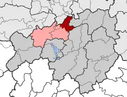 | |
| Coordinates: 39°28′N 21°51′E / 39.467°N 21.850°E | |
| Country | Greece |
| Administrative region | Thessaly |
| Regional unit | Karditsa |
| Municipality | Mouzaki |
| Area | |
| • Municipal unit | 53.9 km2 (20.8 sq mi) |
| Population (2021)[1] | |
| • Municipal unit | 3,176 |
| • Municipal unit density | 59/km2 (150/sq mi) |
| Time zone | UTC+2 (EET) |
| • Summer (DST) | UTC+3 (EEST) |
| Vehicle registration | ΚΑ |
Pamisos (Greek: Πάμισος) is a former municipality in the Karditsa regional unit, Thessaly, Greece, named after Pamisos river. Since the 2011 local government reform it is part of the municipality Mouzaki, of which it is a municipal unit.[2] The municipal unit has an area of 53.854 km2.[3] Population 3,176 (2021). The seat of the municipality was in Agnantero. The municipal unit Pamisos consists of the following communities:[2]
- Agnantero
- Kranea
- Magoula
- Palaiochori
- Rizovouni
References
- ^ "Αποτελέσματα Απογραφής Πληθυσμού - Κατοικιών 2021, Μόνιμος Πληθυσμός κατά οικισμό" [Results of the 2021 Population - Housing Census, Permanent population by settlement] (in Greek). Hellenic Statistical Authority. 29 March 2024.
- ^ a b "ΦΕΚ B 1292/2010, Kallikratis reform municipalities" (in Greek). Government Gazette.
- ^ "Population & housing census 2001 (incl. area and average elevation)" (PDF) (in Greek). National Statistical Service of Greece.