Panjab District
Panjab
پنجاب | |
|---|---|
 Panjab Location within Afghanistan | |
| Coordinates: 34°23′00″N 67°01′00″E / 34.38333°N 67.01667°E | |
| Country | Afghanistan |
| Province | Bamyan |
| Capital | Panjab |
| Government | |
| • Governor | Rustam Ali |
| Elevation | 2,700 m (8,900 ft) |
| Population (2020)[1] | |
• Total | 98,200 |
| Time zone | GMT+04:30 Kabul |
Panjab (Dari: پنجاب) is district in the central part of Bamiyan Province, Afghanistan. The capital is the town of Panjab. Panjab contains 5 valleys (Darai Sia, Darai Nargis, Darai Mahretuspus, Darai Ghurguri and Darai Taquab-Barg), the water running through the 5 valleys meet in the centre of the district. Its population is entirely the Hazara people.[2]
t 2,700 metres above sea level it has the highest altitude in the province, the city of Panjab is located 298 km from the capital Kabul - however travel is difficult especially in winter - the journey takes 14 hours.[2] Two rival parties, Pazdar and Hezb-e-Wahdat, dominate the district and have divided the district between them - there has been fighting between them.[2]
See also
References
- ^ "Bamyan Provincial Profile" (PDF). Ministry of Rural Rehabilitation and Development. Archived from the original on 25 September 2015. Retrieved 24 September 2015.
- ^ a b c UNHCR Sub-Office Central Region - District Profile Punjab
External links
- Map of Settlements IMMAP, September 2011
- Punjab Portal
- Statoids Punjab - (Punjab: Panjab (German); Pendjab, Penjab (French).)
| Districts | 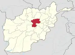 | |
|---|---|---|
| Landforms | ||
| Other | ||