Panorama, Thessaloniki
Panorama
Πανόραμα | |
|---|---|
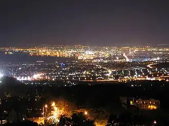 Night view of central Thessaloniki from Panorama. | |
 Panorama Location within the regional unit 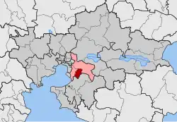 | |
| Coordinates: 40°35′N 23°2′E / 40.583°N 23.033°E | |
| Country | Greece |
| Geographic region | |
| Administrative region | Central Macedonia |
| Regional unit | Thessaloniki |
| Municipality | Pylaia-Chortiatis |
| Area | |
| • Municipal unit | 21.321 km2 (8.232 sq mi) |
| Elevation | 340 m (1,120 ft) |
| Population (2021)[1] | |
| • Municipal unit | 17,679 |
| • Municipal unit density | 830/km2 (2,100/sq mi) |
| Time zone | UTC+2 (EET) |
| • Summer (DST) | UTC+3 (EEST) |
| Postal code | 552 xx |
| Area code(s) | 2310 |
| Vehicle registration | Ν |

Panorama (Greek: Πανόραμα) is a suburb in the Thessaloniki regional unit, Macedonia, Greece. Since the 2011 local government reform it is part of the municipality Pylaia-Chortiatis, of which it is the seat and a municipal unit.[2] Panorama is located at the foot of Mount Chortiatis. The municipal unit has an area of 21.321 km2.[3]
Historical population
| Year | Population |
|---|---|
| 1981 | 4,193 |
| 1991 | 10,278 |
| 2001 | 14,456 |
| 2011 | 17,444 |
| 2021 | 17,679 |
See also
References
- ^ "Αποτελέσματα Απογραφής Πληθυσμού - Κατοικιών 2021, Μόνιμος Πληθυσμός κατά οικισμό" [Results of the 2021 Population - Housing Census, Permanent population by settlement] (in Greek). Hellenic Statistical Authority. 29 March 2024.
- ^ "ΦΕΚ B 1292/2010, Kallikratis reform municipalities" (in Greek). Government Gazette.
- ^ "Population & housing census 2001 (incl. area and average elevation)" (PDF) (in Greek). National Statistical Service of Greece.