Paravola
Paravola
Παραβόλα | |
|---|---|
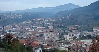 View of the town | |
 Paravola Location within the regional unit 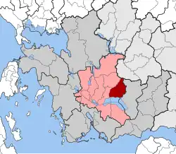 | |
| Coordinates: 38°37′N 21°31′E / 38.617°N 21.517°E | |
| Country | Greece |
| Administrative region | West Greece |
| Regional unit | Aetolia-Acarnania |
| Municipality | Agrinio |
| Area | |
| • Municipal unit | 135.4 km2 (52.3 sq mi) |
| Elevation | 60 m (200 ft) |
| Population (2021)[1] | |
| • Municipal unit | 3,105 |
| • Municipal unit density | 23/km2 (59/sq mi) |
| • Community | 1,408 |
| Time zone | UTC+2 (EET) |
| • Summer (DST) | UTC+3 (EEST) |
| Postal code | 30010 |
Paravola (Greek: Παραβόλα) is a village and a former municipality in Aetolia-Acarnania, West Greece, Greece. Since the 2011 local government reform it is part of the municipality Agrinio, of which it is a municipal unit.[2] The municipal unit has an area of 135.373 km2.[3] Population 3,105 (2021).
References
- ^ "Αποτελέσματα Απογραφής Πληθυσμού - Κατοικιών 2021, Μόνιμος Πληθυσμός κατά οικισμό" [Results of the 2021 Population - Housing Census, Permanent population by settlement] (in Greek). Hellenic Statistical Authority. 29 March 2024.
- ^ "ΦΕΚ B 1292/2010, Kallikratis reform municipalities" (in Greek). Government Gazette.
- ^ "Population & housing census 2001 (incl. area and average elevation)" (PDF) (in Greek). National Statistical Service of Greece.
External links
- Municipality of Paravola (in Greek)