Pedro Osório
Pedro Osório | |
|---|---|
Town | |
 Seal | |
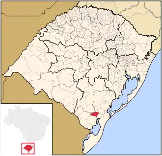 Map of the state of Rio Grande do Sul, Brazil highlighting Pedro Osório | |
| Coordinates: 31°51′51″S 52°49′24″W / 31.86417°S 52.82333°W | |
| Country | Brazil |
| Region | South |
| State | Rio Grande do Sul |
| Micro-region | Pelotas |
| Founded | April 3, 1959 |
| Area | |
• Total | 608.79 km2 (235.06 sq mi) |
| Elevation | 31 m (102 ft) |
| Population (2020 [1]) | |
• Total | 7,706 |
| • Density | 13/km2 (33/sq mi) |
| Demonym | Pedro-osoriense |
| Time zone | UTC−3 (BRT) |
| Website | www |
Pedro Osório is a Brazilian municipality in the southeastern part of the state of Rio Grande do Sul. The population is 7,706 (2020 est.) in an area of 608.79 km2.[2] The municipality was founded on April 3, 1958 from parts of the municipalities of Canguçú and Arroio Grande. Cerrito was separated in 1997.[3]
The municipality is by the Piratini River. Its population is largely of Italian and Lebanese descent.