Peggy, Texas
Peggy, Texas | |
|---|---|
 Peggy  Peggy | |
| Coordinates: 28°44′23″N 98°10′43″W / 28.73972°N 98.17861°W | |
| Country | United States |
| State | Texas |
| County | Atascosa |
| Elevation | 381 ft (116 m) |
| Time zone | UTC-6 (Central (CST)) |
| • Summer (DST) | UTC-5 (CDT) |
| Area code | 830 |
| GNIS feature ID | 1380341[1] |
Peggy is an unincorporated community in Atascosa County, Texas, United States.[1] According to the Handbook of Texas, the community had a population of 22 in 2000. It is located within the San Antonio metropolitan area.
History
Although it is unincorporated, Peggy has a post office, with the ZIP code 78062.[2]
Geography
Peggy is located along the intersection of Farm to Market Road 99 and another unnamed road, 27 mi (43 km) southeast of Jourdanton in southeastern Atascosa County.[3] The nearest major city is San Antonio, located 65 mi (105 km) north via Interstate 37. Campbellton is also located 7 mi (11 km) west, near the next county line.[4]
Education
Public education in the community of Peggy is provided by the Karnes City Independent School District.
References
- ^ a b c U.S. Geological Survey Geographic Names Information System: Peggy, Texas
- ^ USPS – Cities by ZIP Code
- ^ Thonhoff, Robert H. "Peggy, TX". tshaonline.org. Retrieved December 29, 2021.
- ^ "Peggy, Texas". Texas Escapes Online Magazine. Retrieved December 29, 2021.
Municipalities and communities of Atascosa County, Texas, United States | ||
|---|---|---|
| Cities | 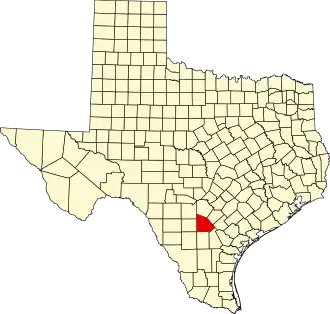 | |
| Town | ||
| CDP | ||
| Other communities | ||
| Ghost towns | ||
| Footnotes | ‡This populated place also has portions in an adjacent county or counties | |