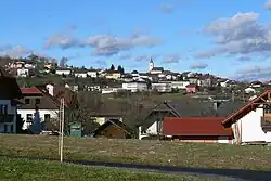
Peilstein im Mühlviertel
Peilstein im Mühlviertel | |
|---|---|
 | |
 Coat of arms | |
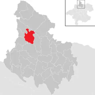 Location in the district | |
 Peilstein im Mühlviertel Location within Austria | |
| Coordinates: 48°37′06″N 13°53′41″E / 48.61833°N 13.89472°E | |
| Country | Austria |
| State | Upper Austria |
| District | Rohrbach |
| Government | |
| • Mayor | Franz Lindinger (ÖVP) |
| Area | |
• Total | 23.29 km2 (8.99 sq mi) |
| Elevation | 584 m (1,916 ft) |
| Population (2018-01-01)[2] | |
• Total | 1,541 |
| • Density | 66/km2 (170/sq mi) |
| Time zone | UTC+1 (CET) |
| • Summer (DST) | UTC+2 (CEST) |
| Postal code | 4153 |
| Area code | 07287 |
| Vehicle registration | RO |
| Website | www.peilstein.at |
Peilstein im Mühlviertel is a municipality in the district of Rohrbach in the Austrian state of Upper Austria.
Population
| Year | Pop. | ±% |
|---|---|---|
| 1925 | 1,741 | — |
| 1948 | 1,766 | +1.4% |
| 1951 | 1,604 | −9.2% |
| 1961 | 1,654 | +3.1% |
| 1971 | 1,638 | −1.0% |
| 1981 | 1,656 | +1.1% |
| 1991 | 1,672 | +1.0% |
| 2001 | 1,674 | +0.1% |
| 2010 | 1,595 | −4.7% |
| 2017 | 1,542 | −3.3% |
References
- ^ "Dauersiedlungsraum der Gemeinden Politischen Bezirke und Bundesländer - Gebietsstand 1.1.2018". Statistics Austria. Retrieved 10 March 2019.
- ^ "Einwohnerzahl 1.1.2018 nach Gemeinden mit Status, Gebietsstand 1.1.2018". Statistics Austria. Retrieved 9 March 2019.
Wikimedia Commons has media related to Peilstein im Mühlviertel.