Petra, Boeotia
Petra
Πέτρα | |
|---|---|
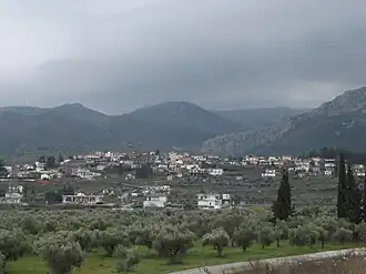 A view of Petra | |
 Petra | |
| Coordinates: 38°22.267′N 23°3.45′E / 38.371117°N 23.05750°E | |
| Country | Greece |
| Administrative region | Central Greece |
| Regional unit | Boeotia |
| Municipality | Aliartos-Thespies |
| Municipal unit | Aliartos |
| Area | |
• Community | 24.451 km2 (9.441 sq mi) |
| Elevation | 190 m (620 ft) |
| Population (2021)[1] | |
• Community | 320 |
| • Density | 13/km2 (34/sq mi) |
| Time zone | UTC+2 (EET) |
| • Summer (DST) | UTC+3 (EEST) |
| Postal code | 320 01 |
| Area code(s) | +30-2368 |
| Vehicle registration | ΒΙ |
Petra (Greek: Πέτρα) is a village and a community of the Aliartos-Thespies municipality.[2] Before the 2011 local government reform it was part of the municipality of Aliartos, of which it was a municipal district.[2] The 2021 census recorded 320 inhabitants in the village.[1] The community of Petra covers an area of 24.451 km2.[3]
History
In July 1829, Petra was the site of the Battle of Petra, the last battle of the Greek War of Independence.
See also
References
- ^ a b "Αποτελέσματα Απογραφής Πληθυσμού - Κατοικιών 2021, Μόνιμος Πληθυσμός κατά οικισμό" [Results of the 2021 Population - Housing Census, Permanent population by settlement] (in Greek). Hellenic Statistical Authority. 29 March 2024.
- ^ a b "ΦΕΚ B 1292/2010, Kallikratis reform municipalities" (in Greek). Government Gazette.
- ^ "Population & housing census 2001 (incl. area and average elevation)" (PDF) (in Greek). National Statistical Service of Greece.
Wikimedia Commons has media related to Petra, Boeotia.