Phra Phutthabat district
Phra Phutthabat
พระพุทธบาท | |
|---|---|
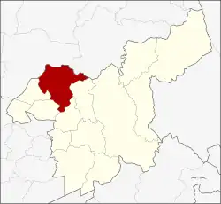 District location in Saraburi province | |
| Coordinates: 14°43′32″N 100°47′43″E / 14.72556°N 100.79528°E | |
| Country | Thailand |
| Province | Saraburi |
| Seat | Phra Phutthabat |
| Area | |
• Total | 287.1 km2 (110.8 sq mi) |
| Population (2000) | |
• Total | 70.354 |
| • Density | 0.25/km2 (0.63/sq mi) |
| Time zone | UTC+7 (ICT) |
| Postal code | 18120 |
| Geocode | 1909 |
Phra Phutthabat (Thai: พระพุทธบาท) is a district (amphoe) in Saraburi province, Thailand.

The district is named after the Phra Phutthabat Temple. Another well-known temple in the district is Wat Tham Krabok, both as a Hmong refugee camp and for its drug rehabilitation program.
Geography
Neighbouring districts are (clockwise from the north): Mueang Lopburi and Phatthana Nikhom of Lopburi province; and Chaloem Phra Kiat, Sao Hai, Ban Mo, Nong Don.
Administration
Phra Phuttabat is divided into nine sub-districts (tambons), which are further divided into 67 villages (mubans).
| No. | Name | Thai name |
|---|---|---|
| 1. | Phra Phutthabat | พระพุทธบาท |
| 2. | Khun Khlon | ขุนโขลน |
| 3. | Than Kasem | ธารเกษม |
| 4. | Na Yao | นายาว |
| 5. | Phu Kham Chan | พุคำจาน |
| No. | Name | Thai name |
|---|---|---|
| 6. | Khao Wong | เขาวง |
| 7. | Huai Pa Wai | ห้วยป่าหวาย |
| 8. | Phu Krang | พุกร่าง |
| 9. | Nong Kae | หนองแก |
External links
- amphoe.com (Thai)