Piraí
Piraí | |
|---|---|
| Município de Piraí | |
 City Hall | |
 Flag  Seal | |
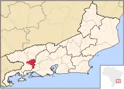 Location of Piraí in the state of Rio de Janeiro | |
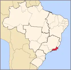
 Piraí Location of Piraí in Brazil | |
| Coordinates: 22°37′44″S 43°53′52″W / 22.62889°S 43.89778°W | |
| Country | |
| Region | Southeast |
| State | |
| Government | |
| • Prefeito | Luiz Antônio da Silva Neves (PDT) |
| Area | |
• Total | 505.466 km2 (195.162 sq mi) |
| Elevation | 387 m (1,270 ft) |
| Population (2020 [1]) | |
• Total | 29,545 |
| Time zone | UTC−3 (BRT) |
| Website | [1] |
Piraí (Portuguese pronunciation: [piɾɐˈi]) is a municipality located in the Brazilian state of Rio de Janeiro. Its population was 29,545 (2020) and its area is 505 km².[2]
Climate
| Climate data for Piraí (1981–2010) | |||||||||||||
|---|---|---|---|---|---|---|---|---|---|---|---|---|---|
| Month | Jan | Feb | Mar | Apr | May | Jun | Jul | Aug | Sep | Oct | Nov | Dec | Year |
| Mean daily maximum °C (°F) | 31.4 (88.5) |
31.2 (88.2) |
30.7 (87.3) |
29.4 (84.9) |
26.3 (79.3) |
25.6 (78.1) |
24.9 (76.8) |
26.7 (80.1) |
26.2 (79.2) |
27.8 (82.0) |
29.0 (84.2) |
30.0 (86.0) |
28.3 (82.9) |
| Mean daily minimum °C (°F) | 19.8 (67.6) |
19.8 (67.6) |
19.5 (67.1) |
18.0 (64.4) |
15.0 (59.0) |
13.1 (55.6) |
12.5 (54.5) |
13.3 (55.9) |
15.1 (59.2) |
16.5 (61.7) |
17.9 (64.2) |
19.4 (66.9) |
16.7 (62.1) |
| Source: Instituto Nacional de Meteorologia[3] | |||||||||||||
References
- ^ IBGE 2020
- ^ IBGE - "Archived copy". Archived from the original on January 9, 2007. Retrieved August 3, 2014.
{{cite web}}: CS1 maint: archived copy as title (link) - ^ "Normais Climatológicas Do Brasil 1981–2010" (in Portuguese). Instituto Nacional de Meteorologia. Retrieved 21 May 2024.
Capital: Rio de Janeiro | |||||||||||
| Mesoregion Baixadas |
|  | |||||||||
| Mesoregion Centro Fluminense |
| ||||||||||
| Mesoregion Metropolitana do Rio de Janeiro |
| ||||||||||
| Mesoregion Noroeste Fluminense |
| ||||||||||
| Mesoregion Norte Fluminense |
| ||||||||||
| Mesoregion Sul Fluminense |
| ||||||||||