Plankenfels
Plankenfels | |
|---|---|
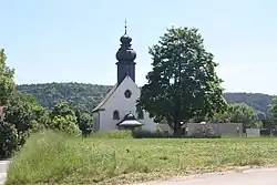 Church of Saint Henry | |
 Coat of arms | |
Location of Plankenfels within Bayreuth district 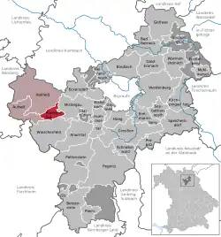 | |
 Plankenfels  Plankenfels | |
| Coordinates: 49°53′N 11°20′E / 49.883°N 11.333°E | |
| Country | Germany |
| State | Bavaria |
| Admin. region | Oberfranken |
| District | Bayreuth |
| Municipal assoc. | Hollfeld |
| Subdivisions | 12 Ortsteile |
| Government | |
| • Mayor (2020–26) | Harald Wich[1] (CSU) |
| Area | |
• Total | 14.01 km2 (5.41 sq mi) |
| Elevation | 390 m (1,280 ft) |
| Population (2024-12-31)[2] | |
• Total | 840 |
| • Density | 60/km2 (160/sq mi) |
| Time zone | UTC+01:00 (CET) |
| • Summer (DST) | UTC+02:00 (CEST) |
| Postal codes | 95515 |
| Dialling codes | 09204 |
| Vehicle registration | BT |
| Website | www.plankenfels.de |
Plankenfels is a municipality in the district of Bayreuth in Bavaria in Germany.
References
- ^ Liste der ersten Bürgermeister/Oberbürgermeister in kreisangehörigen Gemeinden, Bayerisches Landesamt für Statistik, 15 July 2021.
- ^ "Gemeinden, Kreise und Regierungsbezirke in Bayern, Einwohnerzahlen am 31. Dezember 2024; Basis Zensus 2022" [Municipalities, counties, and administrative districts in Bavaria; Based on the 2022 Census] (CSV) (in German). Bayerisches Landesamt für Statistik.
Wikimedia Commons has media related to Plankenfels.
Towns and municipalities in Bayreuth (district) | ||
|---|---|---|
|  | |