Počedělice
Počedělice | |
|---|---|
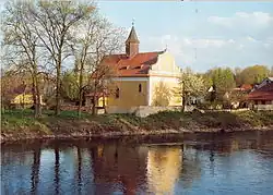 Church of Saint Gall | |
 Flag  Coat of arms | |
 Počedělice Location in the Czech Republic | |
| Coordinates: 50°22′19″N 13°53′16″E / 50.37194°N 13.88778°E | |
| Country | |
| Region | Ústí nad Labem |
| District | Louny |
| First mentioned | 1219 |
| Area | |
• Total | 11.62 km2 (4.49 sq mi) |
| Elevation | 173 m (568 ft) |
| Population (2025-01-01)[1] | |
• Total | 301 |
| • Density | 26/km2 (67/sq mi) |
| Time zone | UTC+1 (CET) |
| • Summer (DST) | UTC+2 (CEST) |
| Postal code | 440 01 |
| Website | www |
Počedělice is a municipality and village in Louny District in the Ústí nad Labem Region of the Czech Republic. It has about 300 inhabitants.
Počedělice lies approximately 7 kilometres (4 mi) east of Louny, 34 km (21 mi) south of Ústí nad Labem, and 50 km (31 mi) north-west of Prague.
Administrative division
Počedělice consists of three municipal parts (in brackets population according to the 2021 census):[2]
- Počedělice (119)
- Orasice (85)
- Volenice (92)
Demographics
| Year | Pop. | ±% |
|---|---|---|
| 1869 | 658 | — |
| 1880 | 680 | +3.3% |
| 1890 | 694 | +2.1% |
| 1900 | 744 | +7.2% |
| 1910 | 766 | +3.0% |
| 1921 | 742 | −3.1% |
| 1930 | 712 | −4.0% |
| 1950 | 546 | −23.3% |
| 1961 | 496 | −9.2% |
| 1970 | 436 | −12.1% |
| 1980 | 347 | −20.4% |
| 1991 | 280 | −19.3% |
| 2001 | 278 | −0.7% |
| 2011 | 262 | −5.8% |
| 2021 | 296 | +13.0% |
| Source: Censuses[3][4] | ||
References
- ^ "Population of Municipalities – 1 January 2025". Czech Statistical Office. 2025-05-16.
- ^ "Public Census 2021 – basic data". Public Database (in Czech). Czech Statistical Office. 2022.
- ^ "Historický lexikon obcí České republiky 1869–2011" (in Czech). Czech Statistical Office. 2015-12-21.
- ^ "Population Census 2021: Population by sex". Public Database. Czech Statistical Office. 2021-03-27.
External links
Wikimedia Commons has media related to Počedělice.