Pocket Creek (Deep River tributary)
| Pocket Creek Tributary to Deep River | |
|---|---|
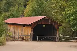 GILLIAM PARK COVERED BRIDGE, LEE COUNTY, NC | |
 Location of Pocket Creek mouth  Pocket Creek (Deep River tributary) (the United States) | |
| Location | |
| Country | United States |
| State | North Carolina |
| County | Lee |
| Physical characteristics | |
| Source | divide between Pocket Creek, Herds Creek, and Little Crane Creek |
| • location | White Hill, North Carolina |
| • coordinates | 35°23′11″N 079°16′46″W / 35.38639°N 79.27944°W[1] |
| • elevation | 475 ft (145 m)[2] |
| Mouth | Deep River |
• location | about 1.5 miles south of Gulf, North Carolina |
• coordinates | 35°32′03″N 079°16′49″W / 35.53417°N 79.28028°W[1] |
• elevation | 208 ft (63 m)[2] |
| Length | 16.44 mi (26.46 km)[3] |
| Basin size | 37.65 square miles (97.5 km2)[4] |
| Discharge | |
| • location | Deep River |
| • average | 42.61 cu ft/s (1.207 m3/s) at mouth with Deep River[4] |
| Basin features | |
| Progression | Deep River → Cape Fear River → Atlantic Ocean |
| River system | Deep River |
| Tributaries | |
| • left | Dry Fork Little Pocket Creek |
| • right | Raccoon Creek |
| Bridges | Villanow Drive, Chris Cole Road, Center Church Road, Covered Bridge Lane, Henley Road, Steel Bridge Road, Carbonton Road (NC 42) |
Pocket Creek is a 16.44 mi (26.46 km) long 3rd order tributary to the Deep River in Lee County, North Carolina. The longest covered bridge (Gilliam Park Covered Bridge) in North Carolina crosses this creek.[5]
Course
Pocket Creek rises in a pond in White Hill, North Carolina and then flows north to join the Deep River about 1.5 miles south of Gulf, North Carolina.[2]
Watershed
Pocket Creek drains 37.65 square miles (97.5 km2) of area, receives about 47.9 in/year of precipitation, has a wetness index of 390.19 and is about 63% forested.[4]
See also
External links
References
- ^ a b "GNIS Detail - Pocket Creek". geonames.usgs.gov. US Geological Survey. Retrieved 18 August 2020.
- ^ a b c "Pocket Creek Topo Map in Lee". TopoZone. Locality, LLC. Retrieved 18 August 2020.
- ^ "ArcGIS Web Application". epa.maps.arcgis.com. US EPA. Retrieved 18 August 2020.
- ^ a b c "Pocket Creek Watershed Report". US EPA Geoviewer. US EPA. Retrieved 18 August 2020.
- ^ Jarvis, Robin (17 October 2019). "The Longest Covered Bridge In North Carolina, At Ole Gilliam Mill Park, Is 140 Feet Long". OnlyInYourState. Onlyinyourstate. Retrieved 18 August 2020.