Port Mitchell, Indiana
Port Mitchell, Indiana | |
|---|---|
 Port Mitchell  Port Mitchell | |
| Coordinates: 41°21′43″N 85°26′20″W / 41.36194°N 85.43889°W | |
| Country | United States |
| State | Indiana |
| County | Noble |
| Township | York |
| Elevation | 899 ft (274 m) |
| Time zone | UTC-5 (Eastern (EST)) |
| • Summer (DST) | UTC-4 (EDT) |
| ZIP code | 46701 |
| Area code | 260 |
| GNIS feature ID | 450580 |
Port Mitchell is an unincorporated community in York Township, Noble County, in the U.S. state of Indiana.[2]
History
Port Mitchell was laid out in 1838.[3]
Geography
Port Mitchell is located at 41°21′43″N 85°26′20″W / 41.36194°N 85.43889°W.
References
- ^ "US Board on Geographic Names". United States Geological Survey. October 25, 2007. Archived from the original on February 2, 2001. Retrieved October 4, 2016.
- ^ "Port Mitchell, Indiana". Geographic Names Information System. United States Geological Survey. Retrieved July 16, 2017.
- ^ Counties of LaGrange and Noble, Indiana: Historical and Biographical. F.A. Battey & Company. 1882. p. 262.
Municipalities and communities of Noble County, Indiana, United States | ||
|---|---|---|
| Cities | 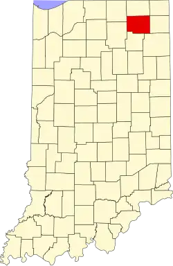 | |
| Towns | ||
| Townships | ||
| CDPs | ||
| Other communities | ||
| Footnotes | ‡This populated place also has portions in an adjacent county or counties | |