Posey Township, Switzerland County, Indiana
Posey Township | |
|---|---|
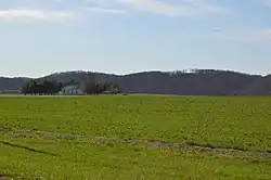 Fields in Egypt Bottom along State Road 156 | |
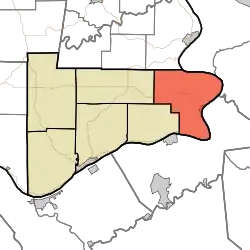 Location in Switzerland County | |
| Coordinates: 38°51′18″N 84°52′16″W / 38.85500°N 84.87111°W | |
| Country | |
| State | |
| County | Switzerland |
| Government | |
| • Type | Indiana township |
| Area | |
• Total | 40.82 sq mi (105.7 km2) |
| • Land | 39.18 sq mi (101.5 km2) |
| • Water | 1.64 sq mi (4.2 km2) 4.02% |
| Elevation | 791 ft (241 m) |
| Population (2020) | |
• Total | 1,576 |
| • Density | 39/sq mi (15/km2) |
| ZIP code | 47038 |
| GNIS feature ID | 453766 |
Posey Township is one of six townships in Switzerland County, Indiana, United States. As of the 2020 census, its population was 1,576 and it contained 653 housing units.[1]
| Census | Pop. | Note | %± |
|---|---|---|---|
| 1890 | 2,253 | — | |
| 1900 | 1,953 | −13.3% | |
| 1910 | 1,633 | −16.4% | |
| 1920 | 1,462 | −10.5% | |
| 1930 | 1,379 | −5.7% | |
| 1940 | 1,419 | 2.9% | |
| 1950 | 1,300 | −8.4% | |
| 1960 | 1,201 | −7.6% | |
| 1970 | 921 | −23.3% | |
| 1980 | 1,149 | 24.8% | |
| 1990 | 1,323 | 15.1% | |
| 2000 | 1,504 | 13.7% | |
| 2010 | 1,779 | 18.3% | |
| 2020 | 1,576 | −11.4% | |
| Source: US Decennial Census[2] | |||
History
The Merit-Tandy Farmstead was listed on the National Register of Historic Places in 1977.[3]
Geography
According to the 2010 census, the township has a total area of 40.82 square miles (105.7 km2), of which 39.18 square miles (101.5 km2) (or 95.98%) is land and 1.64 square miles (4.2 km2) (or 4.02%) is water.[4]
Cities, towns, villages
Unincorporated towns
- Gurley Corner at 38°51′33″N 84°51′30″W / 38.859229°N 84.858282°W
- Quercus Grove at 38°51′12″N 84°55′22″W / 38.853395°N 84.922727°W
- Searcy Crossroads at 38°50′48″N 84°51′29″W / 38.846729°N 84.858004°W
(This list is based on USGS data and may include former settlements.)
Adjacent townships
- Randolph Township, Ohio County (north)
- York Township (southwest)
- Cotton Township (west)
Cemeteries
The township contains these ten cemeteries: Antioch, Bark Works, Concord, Eastview, Grant Brothers, Jack, McNutt, Mead, Munger and Wigal.
School districts
- Switzerland County School Corporation
Political districts
- Indiana's 9th congressional district
- State House District 68
- State Senate District 45
References
- United States Census Bureau 2008 TIGER/Line Shapefiles
- United States Board on Geographic Names (GNIS)
- IndianaMap
- ^ "Explore Census Data". data.census.gov. Retrieved April 12, 2024.
- ^ "Township Census Counts: STATS Indiana".
- ^ "National Register Information System". National Register of Historic Places. National Park Service. July 9, 2010.
- ^ "Population, Housing Units, Area, and Density: 2010 - County -- County Subdivision and Place -- 2010 Census Summary File 1". United States Census. Archived from the original on February 12, 2020. Retrieved May 10, 2013.
External links
Places adjacent to Posey Township, Switzerland County, Indiana | ||||||||||||||||
|---|---|---|---|---|---|---|---|---|---|---|---|---|---|---|---|---|
| ||||||||||||||||
Municipalities and communities of Switzerland County, Indiana, United States | ||
|---|---|---|
| Towns |  | |
| Townships | ||
| CDPs | ||
| Other communities | ||