Prachantakham district
Prachantakham
ประจันตคาม | |
|---|---|
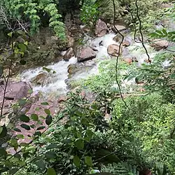 Than Thip Waterfall, Tambon Bu Fai | |
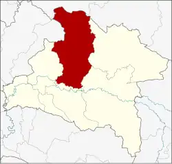 District location in Prachinburi province | |
| Coordinates: 14°3′53″N 101°30′55″E / 14.06472°N 101.51528°E | |
| Country | Thailand |
| Province | Prachinburi |
| Area | |
• Total | 904.005 km2 (349.038 sq mi) |
| Population (2023) | |
• Total | 54,181 |
| • Density | 58.2/km2 (151/sq mi) |
| Time zone | UTC+7 (ICT) |
| Postal code | 25130 |
| Geocode | 2507 |
Prachantakham (Thai: ประจันตคาม, pronounced [prā.t͡ɕān.tā.kʰāːm]) is a district (amphoe) of Prachinburi province, eastern Thailand.
Geography
Neighboring districts are (from the east clockwise): Na Di, Kabin Buri, Si Maha Phot, Mueang Prachinburi of Prachinburi Province; Pak Phli of Nakhon Nayok province; Pak Chong and Wang Nam Khiao of Nakhon Ratchasima province.
The Sankamphaeng Range mountains is in the northern section of this district.
Administration
The district is divided into nine sub-districts (tambons), which are further subdivided into 106 villages (mubans). Prachantakham is a township (thesaban tambon) which covers parts of tambon Prachantakham. There are a further nine tambon administrative organizations (TAO).
| No. | Name | Thai name | Villages | Pop. | |
|---|---|---|---|---|---|
| 1. | Prachantakham | ประจันตคาม | 11 | 8,977 | |
| 2. | Ko Loi | เกาะลอย | 7 | 4,704 | |
| 3. | Ban Hoi | บ้านหอย | 10 | 4,479 | |
| 4. | Nong Saeng | หนองแสง | 6 | 3,394 | |
| 5. | Dong Bang | ดงบัง | 10 | 4,054 | |
| 6. | Kham Tanot | คำโตนด | 18 | 7,054 | |
| 7. | Bu Fai | บุฝ้าย | 13 | 4,859 | |
| 8. | Nong Kaeo | หนองแก้ว | 12 | 4,651 | |
| 9. | Pho Ngam | โพธิ์งาม | 19 | 10,398 |
References
External links
- amphoe.com (Thai)