Prague-Zbraslav
Prague-Zbraslav | |
|---|---|
Municipal District of Prague | |
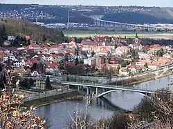 Prague-Zbraslav from the right bank of the Vltava River | |
 Flag  Coat of arms | |
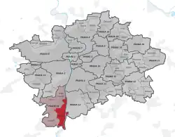 Location of Prague-Zbraslav in Prague | |
| Coordinates: 49°58′03″N 14°23′12″E / 49.9675°N 14.386667°E | |
| Country | Czech Republic |
| Region | Prague |
| Administrative district | Prague 16 |
| Municipal district | Prague 5 |
| Area | |
• Total | 9.85 km2 (3.80 sq mi) |
| Population (2021)[1] | |
• Total | 10,140 |
| • Density | 1,000/km2 (2,700/sq mi) |
| Time zone | UTC+1 (CET) |
| • Summer (DST) | UTC+2 (CEST) |
| Postal code | 156 00 |
Prague-Zbraslav is a district in Prague, Czech Republic. It is situated in the southern part of the city, in the administrative district Prague 16. The cadastral area Zbraslav is part of this district.[2]
References
- ^ "Results of the 2021 Census - Open data". Public Database (in Czech). Czech Statistical Office. 2021-03-27.
- ^ "Základní informace: Městská část Praha - Zbraslav". www.mc-zbraslav.cz. Retrieved 2025-07-20.