Prelà
Prelà | |
|---|---|
| Comune di Prelà | |
 San Giovanni del Grappo Church | |
 Coat of arms | |
Location of Prelà | |
 Prelà Location of Prelà in Italy 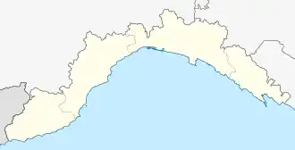 Prelà Prelà (Liguria) | |
| Coordinates: 0143°56′N 7°57′E / 43.933°N 7.950°E | |
| Country | Italy |
| Region | Liguria |
| Province | Province of Imperia (IM) |
| Area | |
• Total | 15.4 km2 (5.9 sq mi) |
| Population (Dec. 2004)[2] | |
• Total | 497 |
| • Density | 32/km2 (84/sq mi) |
| Time zone | UTC+1 (CET) |
| • Summer (DST) | UTC+2 (CEST) |
| Postal code | 18020 |
| Dialing code | 0196 |
Prelà is a comune (municipality) in the Province of Imperia in the Italian region Liguria, located about 100 kilometres (62 mi) southwest of Genoa and about 9 kilometres (6 mi) northwest of Imperia. As of 31 December 2004, it had a population of 497 and an area of 15.4 square kilometres (5.9 sq mi).[3]
Prelà borders the following municipalities: Borgomaro, Carpasio, Dolcedo, Montalto Ligure, and Vasia.
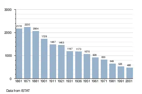
Demographic evolution
Twin towns — sister cities
Prelà is twinned with:
 Châteauneuf-Grasse, France (2005)
References
- ^ "Superficie di Comuni Province e Regioni italiane al 9 ottobre 2011". Italian National Institute of Statistics. Retrieved 16 March 2019.
- ^ "Popolazione Residente al 1° Gennaio 2018". Italian National Institute of Statistics. Retrieved 16 March 2019.
- ^ All demographics and other statistics: Italian statistical institute Istat.