Proti, Serres
Proti
Πρώτη | |
|---|---|
 Proti Location within the regional unit 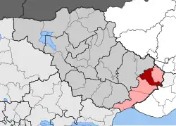 | |
| Coordinates: 40°57′N 24°00′E / 40.950°N 24.000°E | |
| Country | Greece |
| Administrative region | Central Macedonia |
| Regional unit | Serres |
| Municipality | Amfipoli |
| Area | |
| • Municipal unit | 79.2 km2 (30.6 sq mi) |
| Population (2021)[1] | |
| • Municipal unit | 1,546 |
| • Municipal unit density | 20/km2 (51/sq mi) |
| • Community | 907 |
| Time zone | UTC+2 (EET) |
| • Summer (DST) | UTC+3 (EEST) |
| Vehicle registration | ΕΡ |
Proti (Greek: Πρώτη) is a village and a former municipality in the Serres regional unit, Greece. Since the 2011 local government reform it is part of the municipality Amphipoli, of which it is a municipal unit.[2] The municipal unit has an area of 79.241 km2.[3] The population of the municipal unit was 1,546 at the 2021 census.[1]
Near Proti has been found an archaeological site that is probably identified with the Roman station of via Egnatia Domeros.[4] From here comes also various ancient inscriptions, among which a Latin inscription that mentions the inhabitants of two ancient settlements (i.e. "Montani" and "Suritani").[5]
Notable people
- Konstantinos Karamanlis (1907–1998) conservative politician, prime minister (1955–1963, 1974–1980) and president of Greece (1980–1985, 1990–1995)
- Kostas Karamanlis (1956–) conservative politician, prime minister (2004–2009) of Greece
- Christos Govetas, master Greek traditional musician, singer and recording artist, based in Seattle since the 1980s.
References
- ^ a b "Αποτελέσματα Απογραφής Πληθυσμού - Κατοικιών 2021, Μόνιμος Πληθυσμός κατά οικισμό" [Results of the 2021 Population - Housing Census, Permanent population by settlement] (in Greek). Hellenic Statistical Authority. 29 March 2024.
- ^ "ΦΕΚ B 1292/2010, Kallikratis reform municipalities" (in Greek). Government Gazette.
- ^ "Population & housing census 2001 (incl. area and average elevation)" (PDF) (in Greek). National Statistical Service of Greece.
- ^ [1] Archived 2017-04-24 at the Wayback Machine D. C. Samsaris, Historical Geography of Eastern Macedonia during the Antiquity (in Greek), Thessaloniki 1976 (Society for Macedonian Studies), p. 143. ISBN 960-7265-16-5
- ^ D. C. Samsaris, La vallée du Bas-Strymon á l’ époque impériale (Contribution épigraphique á la topographie, l’ onomastique, l’ histoire et aux cultes de la province romaine de Macédoine), Dodona 18 (1989), fasc. 1, p. 295-297, n. 157-162