Pruggern
Pruggern | |
|---|---|
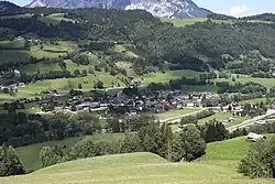 View of Pruggern | |
 Coat of arms | |
 Pruggern Location within Austria | |
| Coordinates: 47°25′24″N 13°52′31″E / 47.42333°N 13.87528°E | |
| Country | Austria |
| State | Styria |
| District | Liezen |
| Area | |
• Total | 21.74 km2 (8.39 sq mi) |
| Elevation | 690 m (2,260 ft) |
| Population (1 January 2016)[1] | |
• Total | 623 |
| • Density | 29/km2 (74/sq mi) |
| Time zone | UTC+1 (CET) |
| • Summer (DST) | UTC+2 (CEST) |
| Postal code | 8965 |
| Area code | 03685 |
| Vehicle registration | GB |
| Website | www.pruggern.at |
Pruggern is a former municipality in the district of Liezen in the Austrian state of Styria. Since the 2015 Styria municipal structural reform, it is part of the municipality Michaelerberg-Pruggern.[2]
Geography
Pruggern lies in the Enns valley between Gröbming and Aich east of Schladming and not far from the entrance to the Sölk Pass.
References