Puerto Rico Highway 151
 Highway 151 | ||||
|---|---|---|---|---|
| Ruta 151 | ||||
| Route information | ||||
| Maintained by Puerto Rico DTPW | ||||
| Length | 12.6 km[1] (7.8 mi) | |||
| Existed | 1953[2]–present | |||
| Major junctions | ||||
| South end | ||||
| ||||
| North end | ||||
| Location | ||||
| Country | United States | |||
| Territory | Puerto Rico | |||
| Municipalities | Villalba | |||
| Highway system | ||||
| ||||
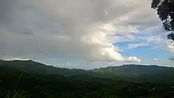
Puerto Rico Highway 151 (PR-151) is a rural road located in the municipality of Villalba, Puerto Rico.[3] This highway begins at PR-150 in downtown Villalba and ends at PR-143 in Caonillas Arriba.[4]
Major intersections
The entire route is located in Villalba.
| Location | km[1] | mi | Destinations | Notes | |
|---|---|---|---|---|---|
| Villalba barrio-pueblo–Hato Puerco Arriba line | 0.0 | 0.0 | Southern terminus of PR-151 | ||
| Hato Puerco Arriba | 0.8 | 0.50 | |||
| 3.3 | 2.1 | ||||
| Hato Puerco Arriba–Caonillas Arriba line | 5.2 | 3.2 | |||
| 9.0– 9.1 | 5.6– 5.7 | ||||
| 9.2 | 5.7 | ||||
| Caonillas Arriba | 12.6 | 7.8 | Northern terminus of PR-151 | ||
| 1.000 mi = 1.609 km; 1.000 km = 0.621 mi | |||||
See also
References
- ^ a b "PR-151" (Map). Google Maps. Retrieved 3 March 2020.
- ^ "Villalba, Memoria Núm. 70" (PDF). Puerto Rico Planning Board (in Spanish). 1955. Retrieved 4 August 2020.
- ^ National Geographic Maps (2011). Puerto Rico (Map). 1:125,000. Adventure Map (Book 3107). Evergreen, Colorado: National Geographic Maps. ISBN 978-1566955188. OCLC 756511572.
- ^ "Tránsito Promedio Diario (AADT)". Puerto Rico Department of Transportation and Public Works (in Spanish). p. 82. Archived from the original on 1 April 2019. Retrieved 31 May 2019.
External links
 Media related to Puerto Rico Highway 151 at Wikimedia Commons