Puerto Rico Highway 16
 Highway 16 | ||||
|---|---|---|---|---|
| Ruta 16 | ||||
| Bulevar Román Baldorioty de Castro | ||||
| Route information | ||||
| Maintained by Puerto Rico DTPW | ||||
| Length | 0.85 km[1] (0.53 mi; 2,800 ft) | |||
| Major junctions | ||||
| South end | Calle Miraflores in Santurce | |||
| North end | ||||
| Location | ||||
| Country | United States | |||
| Territory | Puerto Rico | |||
| Municipalities | San Juan | |||
| Highway system | ||||
| ||||
Puerto Rico Highway 16 (PR-16) is an urban road in Santurce, Puerto Rico. With a length of about 0.85 kilometers (0.53 mi), this highway extends from an interchange with PR-1, PR-26 and Avenida Juan Ponce de León (PR-25) to PR-1 south.[2]
Route description
This is a short road with two lanes per direction on most of its length and is parallel to PR-1 (Expreso Luis Muñoz Rivera), near to the western terminus of PR-26 (Expreso Román Baldorioty de Castro). This road intersects with PR-35 (Avenida Manuel Fernández Juncos) and provides access to Puerto Rico Convention Center and Fernando Luis Ribas Dominicci Airport. This road is called Boulevard Román Baldorioty de Castro.[3]
-
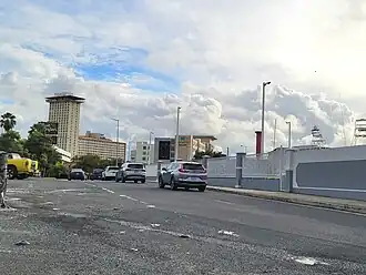 Southbound beginning of PR-16, leaving PR-1 interchange
 -
 PR-16 at its southern terminus
Major intersections
The entire route is located in Santurce, San Juan.
| km[1] | mi | Destinations | Notes | ||
|---|---|---|---|---|---|
| 0.85 | 0.53 | Southern terminus of PR-16; no left turn from Calle Miraflores | |||
| 0.7 | 0.43 | PR-Calle Refugio – Santurce | No access across PR-16; no left turn from PR-16 northbound | ||
| 0.6 | 0.37 | PR-Bulevar del Centro de Convenciones – Santurce | Access to Puerto Rico Convention Center | ||
| 0.4 | 0.25 | PR-Paseo Isla Grande – Santurce | No left turn from PR-16 southbound | ||
| 0.3– 0.2 | 0.19– 0.12 | Access to Fernando Luis Ribas Dominicci Airport | |||
| 0.0 | 0.0 | Northern terminus of PR-16; no access to PR-1 southbound; no exit ramp from PR-26 | |||
| 1.000 mi = 1.609 km; 1.000 km = 0.621 mi | |||||
See also
References
- ^ a b "PR-16" (Map). Google Maps. Retrieved 28 February 2020.
- ^ National Geographic Maps (2011). Puerto Rico (Map). 1:125,000. Adventure Map (Book 3107). Evergreen, Colorado: National Geographic Maps. ISBN 978-1566955188. OCLC 756511572.
- ^ "Boulevard Román Baldorioty de Castro, Santurce". www.cartogiraffe.com. Retrieved 1 February 2022.
External links
 Media related to Puerto Rico Highway 16 at Wikimedia Commons