Puerto Rico Highway 238
 Highway 238 | ||||
|---|---|---|---|---|
| Ruta 238 | ||||
| Desvío Sur de Coamo[1] | ||||
| Route information | ||||
| Maintained by Puerto Rico DTPW | ||||
| Length | 5.0 km[2] (3.1 mi) | |||
| Major junctions | ||||
| West end | ||||
| East end | ||||
| Location | ||||
| Country | United States | |||
| Territory | Puerto Rico | |||
| Municipalities | Coamo | |||
| Highway system | ||||
| ||||
Puerto Rico Highway 238 (PR-238) is an east–west bypass located southeast of downtown Coamo, Puerto Rico.[3] This road extends from PR-153 to PR-14 and is known as Desvío Sur.[1]
Major intersections
The entire route is located in Coamo.
-
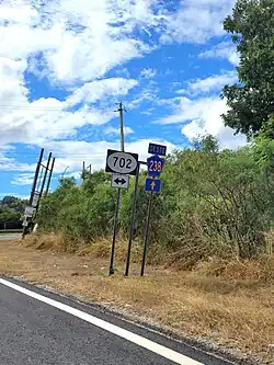 PR-238 at its junction with PR-702 in Palmarejo barrio
| Location | km[2] | mi | Destinations | Notes | |
|---|---|---|---|---|---|
| San Ildefonso | 0.0 | 0.0 | Western terminus of PR-238 | ||
| Palmarejo | 4.3 | 2.7 | All-way stop; access to Palmarejo and Cuyón | ||
| 5.0 | 3.1 | Eastern terminus of PR-238 | |||
| 1.000 mi = 1.609 km; 1.000 km = 0.621 mi | |||||
See also
References
- ^ a b "Desvío Sur de Coamo, San Ildefonso". www.cartogiraffe.com. Retrieved 1 February 2022.
- ^ a b "PR-238" (Map). Google Maps. Retrieved 28 February 2020.
- ^ National Geographic Maps (2011). Puerto Rico (Map). 1:125,000. Adventure Map (Book 3107). Evergreen, Colorado: National Geographic Maps. ISBN 978-1566955188. OCLC 756511572.
External links
 Media related to Puerto Rico Highway 238 at Wikimedia Commons