Puerto Rico Highway 27
  Highway 27 | ||||
|---|---|---|---|---|
| Ruta 27 | ||||
| Avenida José Celso Barbosa | ||||
| Route information | ||||
| Maintained by Puerto Rico DTPW | ||||
| Length | 4.9 km[1] (3.0 mi) | |||
| Major junctions | ||||
| South end | ||||
| ||||
| North end | ||||
| Location | ||||
| Country | United States | |||
| Territory | Puerto Rico | |||
| Municipalities | San Juan | |||
| Highway system | ||||
| ||||
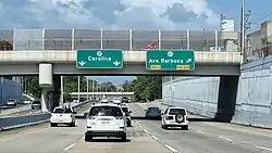
Puerto Rico Highway 27 (PR-27) is a north–south avenue located in San Juan, Puerto Rico, known as Avenida José Celso Barbosa.[2] This highway extends from Avenida 65 de Infantería (PR-3) to Avenida Borinquen (PR-36) in Santurce, east of downtown Río Piedras and Hato Rey.[3]
Major intersections
The entire route is located in San Juan.
| Location | km[1] | mi | Destinations | Notes | |
|---|---|---|---|---|---|
| Sabana Llana Sur–Pueblo line | 0.0 | 0.0 | Southern terminus of PR-27 | ||
| Pueblo | 0.4 | 0.25 | |||
| Universidad | 0.8 | 0.50 | |||
| 1.4– 1.5 | 0.87– 0.93 | Diamond interchange | |||
| Oriente–Hato Rey Central line | 3.6 | 2.2 | |||
| 3.8 | 2.4 | ||||
| Santurce | 4.9 | 3.0 | Northern terminus of PR-27 | ||
| 1.000 mi = 1.609 km; 1.000 km = 0.621 mi | |||||
See also
References
- ^ a b "PR-27" (Map). Google Maps. Retrieved 28 February 2020.
- ^ National Geographic Maps (2011). Puerto Rico (Map). 1:125,000. Adventure Map (Book 3107). Evergreen, Colorado: National Geographic Maps. ISBN 978-1566955188. OCLC 756511572.
- ^ Puerto Rico Department of Transportation and Public Works. "Datos de Transito 2000-2009" (in Spanish). Archived from the original on 1 April 2019. Retrieved 30 March 2019.
External links
 Media related to Puerto Rico Highway 27 at Wikimedia Commons