Puerto Rico Highway 647
 Highway 647 | ||||
|---|---|---|---|---|
| Ruta 647 | ||||
| Carretera Palmira Cabrera de Ibarra[1] | ||||
| Route information | ||||
| Maintained by Puerto Rico DTPW | ||||
| Length | 12.8 km[2] (8.0 mi) | |||
| Existed | 1953[3]–present | |||
| Major junctions | ||||
| South end | ||||
| ||||
| North end | ||||
| Location | ||||
| Country | United States | |||
| Territory | Puerto Rico | |||
| Municipalities | Corozal, Vega Alta | |||
| Highway system | ||||
| ||||
Puerto Rico Highway 647 (PR-647) is a north–south road located between the municipalities of Corozal and Vega Alta in Puerto Rico.[4] With a length of 12.8 km (8.0 mi), it extends from its junction with PR-159 and PR-5568 on the Cibuco–Padilla line in western Corozal,[5] passing through Cienegueta, Candelaria and Bajura barrios until its end at PR-676 in downtown Vega Alta.[6]
Route description
Puerto Rico Highway 647 is mostly a rural road with one lane per direction for its entire length. In Corozal, it has a short length that extends from PR-159 and PR-5568 intersection to the Vega Alta municipal limit and is located entirely within Cibuco barrio.[5] In Vega Alta, PR-647 has a long length, beginning from the Corozal municipal limit and ending at PR-676 in the city center. In this municipality, it crosses Cienegueta, Candelaria and Bajura barrios. PR-647 also crosses the Río Cibuco,[7] and some portions of the Vega State Forest are located on this highway.[8] On 17 March 2022, this road was renamed as Carretera Palmira Cabrera de Ibarra the in honor of the politician from Vega Alta.[1]
-
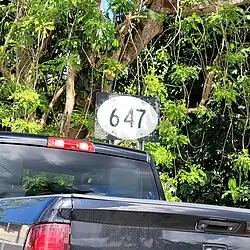 Sign for PR-647 in Cibuco, Corozal, heading north
 -
 PR-647 south near PR-159 and PR-5568 junction in Cienegueta, Vega Alta
 -
 PR-5568 north near PR-159 and PR-647 junction in Padilla, Corozal
History
Prior to its numerical designation, PR-647 was only known as Carretera de Candelaria. The current numerical designation corresponds to the 1953 Puerto Rico highway renumbering, a process implemented by the Puerto Rico Department of Transportation and Public Works (Spanish: Departamento de Transportación y Obras Públicas) that increased the insular highway network to connect existing routes with different locations around Puerto Rico.[3]
Major intersections
| Municipality | Location | km[2] | mi | Destinations | Notes |
|---|---|---|---|---|---|
| Corozal | Padilla–Cibuco line | 0.0 | 0.0 | Southern terminus of PR-647 | |
| Vega Alta | Candelaria | 10.8 | 6.7 | ||
| 10.9 | 6.8 | ||||
| Vega Alta barrio-pueblo | 12.8 | 8.0 | Northern terminus of PR-647 | ||
| 1.000 mi = 1.609 km; 1.000 km = 0.621 mi | |||||
See also
References
- ^ a b "R. C. del S. 254" (PDF) (in Spanish). Senado de Puerto Rico. Archived (PDF) from the original on 7 February 2024. Retrieved 7 February 2024.
- ^ a b "PR-647" (Map). Google Maps. Retrieved 28 February 2020.
- ^ a b "Vega Alta, Memoria Núm. 59" (PDF). Puerto Rico Planning Board (in Spanish). 1955. Retrieved 22 February 2020.
- ^ National Geographic Maps (2011). Puerto Rico (Map). 1:125,000. Adventure Map (Book 3107). Evergreen, Colorado: National Geographic Maps. ISBN 978-1566955188. OCLC 756511572.
- ^ a b "PR-647, Corozal, Puerto Rico". pr.geoview.info. Retrieved 22 February 2020.
- ^ "Tránsito Promedio Diario (AADT)". Transit Data (Datos de Transito) (in Spanish). DTOP PR. p. 119. Archived from the original on 1 April 2019.
- ^ Press, Detroit Free. "PR 647 over CIBUCO RIVER Vega Alta Municipio, Puerto Rico Bridge Inspection Report". Detroit Free Press. Retrieved 9 August 2023.
- ^ "PR-647, Vega Alta, Puerto Rico". pr.geoview.info. Retrieved 22 February 2020.
External links
 Media related to Puerto Rico Highway 647 at Wikimedia Commons