Puerto Rico Highway 693
  Highway 693 | ||||
|---|---|---|---|---|
| Ruta 693 | ||||
| Route information | ||||
| Maintained by Puerto Rico DTPW | ||||
| Length | 15.4 km[1] (9.6 mi) | |||
| Existed | 1953[2]–present | |||
| Major junctions | ||||
| South end | ||||
| North end | ||||
| Location | ||||
| Country | United States | |||
| Territory | Puerto Rico | |||
| Municipalities | Dorado, Vega Alta | |||
| Highway system | ||||
| ||||
| ||||
Puerto Rico Highway 693 (PR-693) is a road located between the municipalities of Dorado, Puerto Rico and Vega Alta, passing through downtown Dorado.[3] It begins at its intersection with PR-2 and PR-165 in Río Lajas and ends at PR-690 in Sabana.[4] It is a short divided highway in southern Dorado, which serves as an alternate route for PR-165 west of Río de la Plata.
-
 Puerto Rico Highway 693 south in downtown Dorado
 -
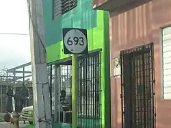
.jpg) Puerto Rico Highway 693 north in Higuillar, Dorado
Puerto Rico Highway 693 north in Higuillar, Dorado
Major intersections
-
.jpg)
-
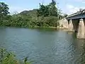 View of PR-2 bridge over the La Plata River between Dorado and Toa Baja from PR-693
 -
 PR-2 west near PR-165 and PR-693 intersection in La Virgencita
| Municipality | Location | km[1] | mi | Destinations | Notes |
|---|---|---|---|---|---|
| Dorado | Río Lajas | 0.0 | 0.0 | Southern terminus of PR-693 | |
| Maguayo | 0.5 | 0.31 | Puente del Río Nuevo over the Río Nuevo[5] | ||
| 1.4– 1.7 | 0.87– 1.1 | PR-22 exit 24; partial cloverleaf interchange | |||
| 2.6 | 1.6 | ||||
| Higuillar | 3.2 | 2.0 | Seagull intersection | ||
| 5.5 | 3.4 | ||||
| Dorado barrio-pueblo | 6.0 | 3.7 | |||
| 6.4 | 4.0 | One-way street; southbound access via Calle Bailen | |||
| Higuillar | 7.2 | 4.5 | |||
| 7.4– 7.5 | 4.6– 4.7 | ||||
| 8.2 | 5.1 | ||||
| 8.8 | 5.5 | ||||
| Vega Alta | Sabana | 14.1 | 8.8 | ||
| 15.4 | 9.6 | Northern terminus of PR-693 | |||
| 1.000 mi = 1.609 km; 1.000 km = 0.621 mi | |||||
Related route
Highway 6693 | |
|---|---|
| Location | Dorado |
| Length | 1.3 km[6] (0.81 mi) |
Puerto Rico Highway 6693 (PR-6693) is a spur of PR-693 located in Dorado. This road is a bypass located south of the downtown area and goes from PR-693 to PR-696.[3] The entire route is located in Higuillar, Dorado.
-
 PR-693 south approaching PR-6693 intersection
 -
 PR-6165 and PR-6693 signs in Dorado barrio-pueblo
| km[6] | mi | Destinations | Notes | ||
|---|---|---|---|---|---|
| 0.0 | 0.0 | Western terminus of PR-6693; access to Hyatt Residence Club Dorado | |||
| 0.6– 0.7 | 0.37– 0.43 | Southern terminus of PR-699 | |||
| 1.3 | 0.81 | Eastern terminus of PR-6693 | |||
| 1.000 mi = 1.609 km; 1.000 km = 0.621 mi | |||||
See also
References
- ^ a b "PR-693" (Map). Google Maps. Retrieved 28 February 2020.
- ^ "Dorado, Memoria Núm. 58" (PDF). Puerto Rico Planning Board (in Spanish). 1955. Retrieved 3 August 2020.
- ^ a b National Geographic Maps (2011). Puerto Rico (Map). 1:125,000. Adventure Map (Book 3107). Evergreen, Colorado: National Geographic Maps. ISBN 978-1566955188. OCLC 756511572.
- ^ Puerto Rico Department of Transportation and Public Works. "Datos de Transito 2000-2009" (in Spanish). pp. 123–124. Archived from the original on 1 April 2019. Retrieved 29 April 2019.
- ^ Luis F. Pumarada O’Neill (1991). "Los Puentes Históricos de Puerto Rico" (PDF) (in Spanish). p. 49. Retrieved 10 March 2020.
- ^ a b "PR-6693" (Map). Google Maps. Retrieved 28 February 2020.
External links
Wikimedia Commons has media related to Puerto Rico Highway 693 and Puerto Rico Highway 6693.