Quebec Route 391
 Route 391 | ||||
|---|---|---|---|---|
 | ||||
| Route information | ||||
| Maintained by Transports Québec | ||||
| Length | 90 km[1] (56 mi) | |||
| Major junctions | ||||
| South end | ||||
| North end | ||||
| Location | ||||
| Country | Canada | |||
| Province | Quebec | |||
| Major cities | Rouyn-Noranda | |||
| Highway system | ||||
| ||||
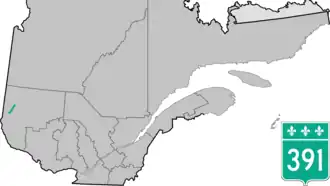
Route 391 is a provincial highway located in the Abitibi-Témiscamingue region in southwestern Quebec near the Ontario border. The 90 km (56 mi) road runs from the junction of Route 101 near St-Édouard-de-Fabre and ends in Rouyn-Noranda at the junction of Route 117. Between Lorrainville and Laverlochère-Angliers, it overlaps Route 382. Near Rollet, it is also concurrent with Route 101.
Towns along Route 391
.jpg)
- Saint-Édouard-de-Fabre
- Béarn
- Lorrainville
- Laverlochère-Angliers
- Saint-Eugène-de-Guigues
- Guérin
- Rémigny
- Rouyn-Noranda
See also
References
- ^ Ministère des transports, "Distances routières", page 95, Les Publications du Québec, 2005
External links
- Official Transports Quebec Map Archived 2020-11-16 at the Wayback Machine (in French)
- Route 391 on Google Maps