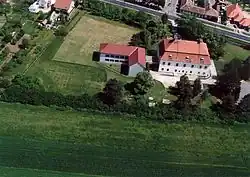
Rábapaty
Rábapaty | |
|---|---|
 | |
 Coat of arms | |
 Rábapaty Location of Rábapaty in Hungary | |
| Coordinates: 47°18′07″N 16°55′39″E / 47.30202°N 16.92755°E | |
| Country | Hungary |
| Region | Western Transdanubia |
| County | Vas |
| Subregion | Sárvári |
| Rank | Village |
| Area | |
• Total | 21.41 km2 (8.27 sq mi) |
| Population (1 January 2008)[2] | |
• Total | 1,755 |
| • Density | 82/km2 (210/sq mi) |
| Time zone | UTC+1 (CET) |
| • Summer (DST) | UTC+2 (CEST) |
| Postal code | 9641 |
| Area code | +36 95 |
| KSH code | 26073[1] |
| Website | www.rabapaty.hu |
Rábapaty is a village in Vas county, Hungary.
References
- ^ a b Rábapaty at the Hungarian Central Statistical Office (Hungarian).
- ^ Rábapaty at the Hungarian Central Statistical Office (Hungarian). 1 January 2008
47°18′N 16°56′E / 47.300°N 16.933°E