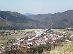
Rajecká Lesná
Rajecká Lesná | |
|---|---|
 | |
 Flag | |
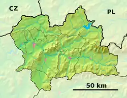 Rajecká Lesná Location of Rajecká Lesná in the Žilina Region  Rajecká Lesná Location of Rajecká Lesná in Slovakia | |
| Coordinates: 49°03′N 18°39′E / 49.05°N 18.65°E | |
| Country | |
| Region | |
| District | Žilina District |
| First mentioned | 1474 |
| Area | |
• Total | 39.27 km2 (15.16 sq mi) |
| Elevation | 508 m (1,667 ft) |
| Population (2021)[3] | |
• Total | 1,219 |
| Time zone | UTC+1 (CET) |
| • Summer (DST) | UTC+2 (CEST) |
| Postal code | 131 5[2] |
| Area code | +421 41[2] |
| Car plate | ZA |
| Website | www |
Rajecká Lesná (formerly Fryvald-Lesná; Hungarian: Frivaldnádas, until 1906 Trsztyennafrivald) is a village and municipality in Žilina District in the Žilina Region of northern Slovakia.
History
In historical records, the village was first mentioned in 1474. Rajecka Lesna has been a place of pilgrimage since the 15th century. The largest pilgrimage takes place on 8 September, the feast of Virgin Mary's Nativity.
Geography
The municipality lies at an altitude of 513 metres and covers an area of 39.264 km². It has a population of about 1300 people.
References
- ^ "Hustota obyvateľstva - obce [om7014rr_ukaz: Rozloha (Štvorcový meter)]". www.statistics.sk (in Slovak). Statistical Office of the Slovak Republic. 2022-03-31. Retrieved 2022-03-31.
- ^ a b c "Základná charakteristika". www.statistics.sk (in Slovak). Statistical Office of the Slovak Republic. 2015-04-17. Retrieved 2022-03-31.
- ^ "Počet obyvateľov podľa pohlavia - obce (ročne)". www.statistics.sk (in Slovak). Statistical Office of the Slovak Republic. 2022-03-31. Retrieved 2022-03-31.
External links
Wikimedia Commons has media related to Rajecká Lesná.