Randall, Indiana
Randall, Indiana | |
|---|---|
 Vermillion County's location in Indiana | |
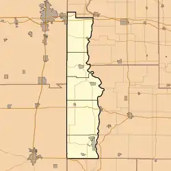 Randall Randall's location in Vermillion County | |
| Coordinates: 39°46′30″N 87°31′21″W / 39.77500°N 87.52250°W | |
| Country | United States |
| State | Indiana |
| County | Vermillion |
| Township | Helt |
| Elevation | 617 ft (188 m) |
| Time zone | UTC-5 (Eastern (EST)) |
| • Summer (DST) | UTC-4 (EDT) |
| ZIP code | 47847 |
| Area code | 765 |
| GNIS feature ID | 441760 |
Randall is a former town in Helt Township, Vermillion County, in the U.S. state of Indiana.[2] Randall is also 1.6 miles northwest of another extinct town: Toronto, on W County Road 700 S. The nearest extant community is the town of Dana, to the northeast.
History
The post office at Randall was established in 1858 and discontinued in 1872.[3] The community was named in honor of the Randall family of settlers.[4]
Geography
Randall is located at 39°46′30″N 87°31′21″W / 39.77500°N 87.52250°W.
References
- ^ "US Board on Geographic Names". United States Geological Survey. October 25, 2007. Retrieved July 18, 2016.
- ^ "Randall, Indiana". Geographic Names Information System. United States Geological Survey, United States Department of the Interior. Retrieved July 18, 2016.
- ^ "Vermillion County". Jim Forte Postal History. Retrieved October 1, 2015.
- ^ Baker, Ronald L. (October 1995). From Needmore to Prosperity: Hoosier Place Names in Folklore and History. Indiana University Press. p. 276. ISBN 978-0-253-32866-3.
...for the local Randall family...
Municipalities and communities of Vermillion County, Indiana, United States | ||
|---|---|---|
| City | | |
| Towns | ||
| Townships | ||
| CDPs | ||
| Other communities | ||
| Ghost towns | ||
| Footnotes | ‡This populated place also has portions in an adjacent county or counties | |