Red Line, Iowa
Red Line, Iowa | |
|---|---|
 Red Line, Iowa | |
| Coordinates: 41°43′02″N 95°09′04″W / 41.71722°N 95.15111°W | |
| Country | United States |
| State | Iowa |
| County | Shelby |
| Elevation | 1,266 ft (386 m) |
| Time zone | UTC-6 (Central (CST)) |
| • Summer (DST) | UTC-5 (CDT) |
| Area code | 712 |
| GNIS feature ID | 460552[1] |
Red Line is an unincorporated community in Polk Township, Shelby County, Iowa, United States.[1]
Geography
Red Line is located along County Highway M56 10 miles (16 km) east-northeast of Harlan.[2]
History
Red Line's population was 10 in 1940.[3]
See also
References
- ^ a b "Red Line". Geographic Names Information System. United States Geological Survey, United States Department of the Interior.
- ^ "Shelby County, Iowa Highway and Transportation Map" (PDF). Iowa Department of Transportation. January 1, 2017. Retrieved July 13, 2018.
- ^ The Attorneys List. United States Fidelity and Guaranty Company, Attorney List Department. 1940. p. 310.
Municipalities and communities of Shelby County, Iowa, United States | ||
|---|---|---|
| Cities | 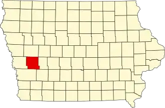 | |
| CDPs | ||
| Other communities | ||
| Footnotes | ‡This populated place also has portions in an adjacent county or counties | |