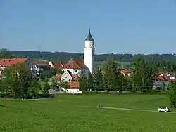
Dietmannsried
Dietmannsried | |
|---|---|
 Dietmannsried | |
 Coat of arms | |
Location of Dietmannsried within Oberallgäu district 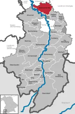 | |
 Dietmannsried  Dietmannsried | |
| Coordinates: 47°49′N 10°17′E / 47.817°N 10.283°E | |
| Country | Germany |
| State | Bavaria |
| Admin. region | Schwaben |
| District | Oberallgäu |
| Government | |
| • Mayor (2020–26) | Werner Endres[1] |
| Area | |
• Total | 53.67 km2 (20.72 sq mi) |
| Elevation | 682 m (2,238 ft) |
| Population (2024-12-31)[2] | |
• Total | 8,498 |
| • Density | 160/km2 (410/sq mi) |
| Time zone | UTC+01:00 (CET) |
| • Summer (DST) | UTC+02:00 (CEST) |
| Postal codes | 87463 |
| Dialling codes | 08374 |
| Vehicle registration | OA |
| Website | www.dietmannsried.de |
Dietmannsried is a municipality in the district of Oberallgäu in Bavaria in Germany.
Sister cities
References
- ^ Liste der ersten Bürgermeister/Oberbürgermeister in kreisangehörigen Gemeinden, Bayerisches Landesamt für Statistik, 15 July 2021.
- ^ "Gemeinden, Kreise und Regierungsbezirke in Bayern, Einwohnerzahlen am 31. Dezember 2024; Basis Zensus 2022" [Municipalities, counties, and administrative districts in Bavaria; Based on the 2022 Census] (CSV) (in German). Bayerisches Landesamt für Statistik.