River Greta (Lune)
| River Greta | |
|---|---|
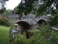 Bridge over the River Greta in Burton-in-Lonsdale | |
| Location | |
| Country | United Kingdom |
| Part | England |
| County | Lancashire |
| Physical characteristics | |
| Source | |
| • location | Ingleton |
| • coordinates | 54°09′19″N 2°28′00″W / 54.1552°N 2.4668°W |
| Mouth | |
• location | Thurland Castle |
• coordinates | 54°08′56″N 2°36′47″W / 54.149°N 2.613°W |
| Length | 22 km (14 mi)[1] |
| Basin features | |
| River system | River Lune[2] |
The River Greta is a river flowing through Lancashire and North Yorkshire in the north of England.
The river is formed by the confluence of the River Twiss and the River Doe at Ingleton.[3]
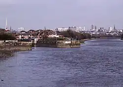
From Ingleton, the Greta travels westwards through Burton-in-Lonsdale and, over the border in Lancashire, Cantsfield and Wrayton, passing Thurland Castle, where the Greta flows into the River Lune.[4]
References
- ^ "Greta". environment.data.gov.uk. Retrieved 22 June 2017.
- ^ "Lune Rivers Trust INNS strategic plan 2014" (PDF). luneriverstrust.org.uk. p. 2. Retrieved 22 June 2017.
- ^ Bagshaw, Mike (2010). Go slow Yorkshire dales & moors : local, characterful guides to Britain's special places (1 ed.). Chalfont St. Peter: Bradt Travel Guides. p. 12. ISBN 978-1-84162-323-8.
- ^ "OL2" (Map). Yorkshire Dales Southern & Western Area. 1:25,000. Explorer. Ordnance Survey. 2016. ISBN 9780319263310.