Steyr (river)
| Steyr | |
|---|---|
 | |
 | |
| Location | |
| Country | Austria |
| State | Upper Austria |
| Physical characteristics | |
| Source | |
| • location | at Hinterstoder |
| • coordinates | 47°38′32″N 14°05′05″E / 47.6422°N 14.0846°E |
| Mouth | |
• location | in Steyr into the Enns |
• coordinates | 48°02′33″N 14°25′19″E / 48.0424°N 14.4220°E |
| Length | 68.3 km (42.4 mi) [1] |
| Basin size | 917 km2 (354 sq mi) |
| Basin features | |
| Progression | Enns→ Danube→ Black Sea |
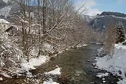
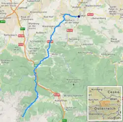
The Steyr (German: [ˈʃtaɪɐ] ⓘ) is a river in Upper Austria.[2] Its length is approx. 68 km (42 mi). Its drainage basin is 917 km2 (354 sq mi).[3]
Rising in the Totes Gebirge at Hinterstoder,[2] it flows into the Enns in the town Steyr. There both rivers form a "Y".[4] The city of Steyr uses this "Y" for marketing purposes.
Tributaries
- Krumme Steyr
- Teichl
- Krumme Steyrling
References
- ^ DORIS Atlas (Upper Austria)
- ^ a b "Steyr source" (Map). Google Maps. Retrieved 13 February 2020.
- ^ "Flächenverzeichnis der Flussgebiete: Ennsgebiet" (PDF). Beiträge zur Hydrografie Österreichs Heft 61. October 2011. p. 67.
- ^ "Steyr mouth" (Map). Google Maps. Retrieved 13 February 2020.
External links
 Media related to Steyr River at Wikimedia Commons