Rucava Municipality
Rucava Municipality
Rucavas novads | |
|---|---|
 Flag 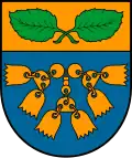 Coat of arms | |
 | |
| Country | |
| Formed | 2009 |
| Centre | Rucava |
| Government | |
| • Council Chair | Jānis Veits (For The Development of the Municipality) |
| Area | |
• Total | 448.16 km2 (173.04 sq mi) |
| • Land | 434.43 km2 (167.73 sq mi) |
| • Water | 13.73 km2 (5.30 sq mi) |
| Population (2021)[2] | |
• Total | 1,505 |
| • Density | 3.4/km2 (8.7/sq mi) |
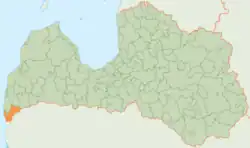
Rucava Municipality (Latvian: Rucavas novads) is a former municipality in Courland, Latvia. The municipality was formed in 2009 by merging Dunika Parish and Rucava Parish, the administrative centre being Rucava. The population in 2020 was 1,451.[3]
Rucava Municipality ceased to exist on 1 July 2021, when it was merged into the newly formed South Kurzeme Municipality.[4]
See also
References
- ^ Central Statistical Bureau of Latvia https://data.stat.gov.lv/pxweb/lv/OSP_PUB/START__ENV__DR__DRT/DRT010/. Retrieved 25 February 2021.
{{cite web}}: Missing or empty|title=(help) - ^ Central Statistical Bureau of Latvia https://data.stat.gov.lv/pxweb/lv/OSP_PUB/START__POP__IR__IRS/IRD060/. Retrieved 15 June 2021.
{{cite web}}: Missing or empty|title=(help) - ^ "ISG020. Population number and its change by statistical region, city, town, 21 development centres and county". Central Statistical Bureau of Latvia. 2020-01-01. Retrieved 2021-02-12.
- ^ "Administratīvo teritoriju un apdzīvoto vietu likums". LIKUMI.LV (in Latvian). Retrieved 2024-08-08.
Wikimedia Commons has media related to Rucava Municipality.
56°09′33″N 21°09′43″E / 56.15917°N 21.16194°E