Ruská Kajňa
Ruská Kajňa | |
|---|---|
 | |
 Flag | |
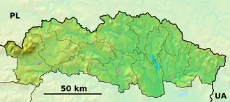 Ruská Kajňa Location of Ruská Kajňa in the Prešov Region  Ruská Kajňa Location of Ruská Kajňa in Slovakia | |
| Coordinates: 49°07′N 21°50′E / 49.12°N 21.83°E | |
| Country | |
| Region | |
| District | Humenné District |
| First mentioned | 1582 |
| Area | |
• Total | 5.11 km2 (1.97 sq mi) |
| Elevation | 203 m (666 ft) |
| Population (2021)[3] | |
• Total | 100 |
| Time zone | UTC+1 (CET) |
| • Summer (DST) | UTC+2 (CEST) |
| Postal code | 940 7[2] |
| Area code | +421 57[2] |
| Car plate | HE |
| Website | ruska-kajna |
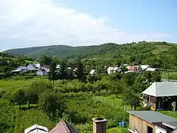
Ruská Kajňa (Rusyn: Руська Кайня is a village and municipality in Humenné District in the Prešov Region of north-east Slovakia.
Geography
The municipality lies at an altitude of 223 metres and covers an area of 5.11 km2. It has a population of about 130 people.
References
- ^ "Hustota obyvateľstva - obce [om7014rr_ukaz: Rozloha (Štvorcový meter)]". www.statistics.sk (in Slovak). Statistical Office of the Slovak Republic. 2022-03-31. Retrieved 2022-03-31.
- ^ a b c "Základná charakteristika". www.statistics.sk (in Slovak). Statistical Office of the Slovak Republic. 2015-04-17. Retrieved 2022-03-31.
- ^ "Počet obyvateľov podľa pohlavia - obce (ročne)". www.statistics.sk (in Slovak). Statistical Office of the Slovak Republic. 2022-03-31. Retrieved 2022-03-31.