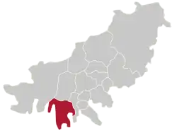
Saha District
Saha
사하구 | |
|---|---|
| Korean transcription(s) | |
| • Hanja | 沙下區 |
| • Revised Romanization | Saha-gu |
| • McCune–Reischauer | Saha-ku |
 | |
 Flag | |
 | |
| Country | South Korea |
| Region | Yeongnam |
| Provincial level | Busan |
| Administrative divisions | 16 administrative dong |
| Government | |
| • Mayor | Lee Gap-jun (이갑준) |
| Area | |
• Total | 41.77 km2 (16.13 sq mi) |
| Population (2024[1]) | |
• Total | 292,717 |
| • Density | 7,000/km2 (18,000/sq mi) |
| • Dialect | Gyeongsang |
| Website | Saha District Office |
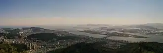
Saha District (Korean: 사하구; RR: Saha-gu) is a gu in western Busan, South Korea. It has an area of 40.89 km², and a population of about 375,000. About a third of the area is forest land. Saha District became a gu of Busan in 1983. It is home to the Seunghak Campus of Dong-A University.
Administrative divisions
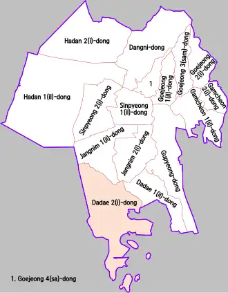
Saha District is divided into 8 legal dong, which all together comprise 16 administrative dong, as follows:
- Goejeong-dong (4 administrative dong)
- Dangni-dong
- Hadan-dong (2 administrative dong)
- Sinpyeong-dong (2 administrative dong)
- Jangnim-dong (2 administrative dong)
- Dadae-dong (2 administrative dong)
- Gupyeong-dong
- Gamcheon-dong (2 administrative dong)
Sister cities
See also
References
- ^ "Population statistics". Korea Ministry of the Interior and Safety. 2024.
External links
Wikimedia Commons has media related to Saha-gu, Busan.
- Saha District-City of Busan (in English)
- Saha District website (in English)