Saint-Éphrem-de-Beauce
Saint-Éphrem-de-Beauce | |
|---|---|
 | |
 Flag | |
| Motto: Proud of our municipality! (French: Fiers de notre municipalité!) | |
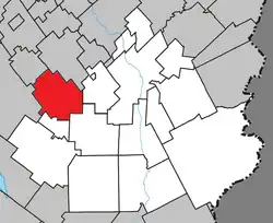 Location within Beauce-Sartigan RCM. | |
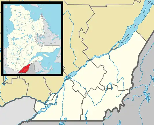 Saint-Éphrem-de-Beauce Location in southern Quebec. | |
| Coordinates: 46°04′N 70°57′W / 46.067°N 70.950°W[1] | |
| Country | |
| Province | |
| Region | Chaudière-Appalaches |
| RCM | Beauce-Sartigan |
| Constituted | 24 December 1997 |
| Government | |
| • Mayor | Carl Gilbert |
| • Federal riding | Beauce |
| • Prov. riding | Beauce-Sud |
| Area | |
• Total | 119.00 km2 (45.95 sq mi) |
| • Land | 118.90 km2 (45.91 sq mi) |
| Population (2021)[3] | |
• Total | 2,323 |
| • Density | 19.5/km2 (51/sq mi) |
| • Pop 2011–2021 | |
| • Dwellings | 1,054 |
| Time zone | UTC−5 (EST) |
| • Summer (DST) | UTC−4 (EDT) |
| Postal code(s) | |
| Area codes | 418 and 581 |
| Highways | |
| Website | www |
Saint-Éphrem-de-Beauce (French pronunciation: [sɛ̃t‿efʁɛm də bos], lit. 'Saint Éphrem of Beauce') is a municipality in the Municipalité régionale de comté de Beauce-Sartigan in Quebec, Canada. It is part of the Chaudière-Appalaches region and the population was 2,567 as of the Canadian census of 2011. It was named after Ephrem the Syrian.
History
- 1855 : Constitution of the municipalité de canton de Tring
- 1866 : The municipalité de paroisse de Saint-Éphrem-de-Tring is created during the breakup of Tring.
- 1870 : Saint-Éphrem-de-Tring changes its status to municipality.
- 1897 : The municipalité de village de Saint-Éphrem-de-Tring detaches from the municipality.
- 1956 : The municipality of Saint-Ephrem de Tring changed its name to municipalité de paroisse de Saint-Éphrem-de-Beauce
- 1997 : Fusion between Saint-Éphrem-de-Tring and Saint-Éphrem-de-Beauce to become the municipalité de Saint-Éphrem-de-Beauce.
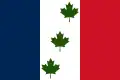
Flag origin
It incorporates the same colours as the French flag as a sign of the community's French identity. The three green maple leaves on a white background represent its maple country location, while the number three is for the founding communities of Saint-Isidore, Sainte-Marie and Beauceville. The flag was adopted in 1955.
Geography
Saint-Éphrem-de-Beauce lies to the south-west of Saint-Georges, on the banks of the Rivière des Hamel, which flows from the south-west of the municipality towards the north-east, where it meets the Bras Saint-Victor, which crosses the municipality from south to north.
The municipality covers an area of approximately 120 square kilometres.
Economy
Some important industries are there so:
- René Matériaux Composites
- Porte Baillargeon
- Industrie PHL
- Filature Lemieux
- Transport Couture
See also
References
- ^ "Banque de noms de lieux du Québec: Reference number 338811". toponymie.gouv.qc.ca (in French). Commission de toponymie du Québec.
- ^ a b "Répertoire des municipalités: Geographic code 29112". www.mamh.gouv.qc.ca (in French). Ministère des Affaires municipales et de l'Habitation.
- ^ a b "Census Profile, 2021 Census, Statistics Canada – Validation Error".
Places adjacent to Saint-Éphrem-de-Beauce | ||||||||||||||||
|---|---|---|---|---|---|---|---|---|---|---|---|---|---|---|---|---|
| ||||||||||||||||
| Cities & towns | |
|---|---|
| Municipalities | |
| Parishes | |
| Villages | |
| |