Samoklęski Duże
Samoklęski Duże | |
|---|---|
Village | |
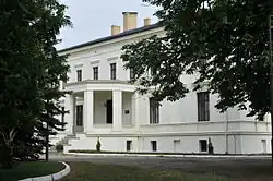 Palace in Samoklęski Duże | |
 Samoklęski Duże | |
| Coordinates: 53°5′N 17°42′E / 53.083°N 17.700°E | |
| Country | |
| Voivodeship | Kuyavian-Pomeranian |
| County | Nakło |
| Gmina | Szubin |
| First mentioned | 1337 |
| Population | 493 |
| Time zone | UTC+1 (CET) |
| • Summer (DST) | UTC+2 (CEST) |
| Vehicle registration | CNA |
Samoklęski Duże [samɔˈklɛ̃ski ˈduʐɛ] is a village in the administrative district of Gmina Szubin, within Nakło County, Kuyavian-Pomeranian Voivodeship, in north-central Poland.[1]
History
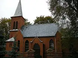
The oldest known mention of the village comes from 1337, when it was part of the Piast-ruled Kingdom of Poland. The Saint Bartholomew Catholic parish was established in the 14th century. Samoklęski Duże was a private village of Polish nobility, administratively located in the Kcynia County in the Kalisz Voivodeship in the Greater Poland Province of the Polish Crown.[2]
References
- ^ "Główny Urząd Statystyczny" [Central Statistical Office] (in Polish). To search: Select "Miejscowości (SIMC)" tab, select "fragment (min. 3 znaki)" (minimum 3 characters), enter town name in the field below, click "WYSZUKAJ" (Search).
- ^ Atlas historyczny Polski. Wielkopolska w drugiej połowie XVI wieku. Część I. Mapy, plany (in Polish). Warsaw: Institute of History, Polish Academy of Sciences. 2017. p. 1b.