Sankt Blasen
Sankt Blasen | |
|---|---|
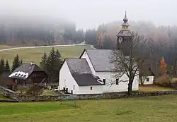 Saint Martin church in Sankt Blasen | |
 Coat of arms | |
 Sankt Blasen Location within Austria | |
| Coordinates: 47°05′00″N 14°18′00″E / 47.08333°N 14.30000°E | |
| Country | Austria |
| State | Styria |
| District | Murau |
| Area | |
• Total | 26.66 km2 (10.29 sq mi) |
| Elevation | 957 m (3,140 ft) |
| Population (1 January 2016)[1] | |
• Total | 552 |
| • Density | 21/km2 (54/sq mi) |
| Time zone | UTC+1 (CET) |
| • Summer (DST) | UTC+2 (CEST) |
| Postal code | 8812, 8813 |
| Area code | 03585 |
| Vehicle registration | MU |
| Website | www.st-blasen.steiermark.at |
Sankt Blasen is a former municipality in the district of Murau in the Austrian state of Styria. Since the 2015 Styria municipal structural reform, it is part of the municipality Sankt Lambrecht.[2]
Geography
Sankt Blasen lies in the mountains that form the boundary between Styria and Carinthia.
References