Sauldre
| Sauldre | |
|---|---|
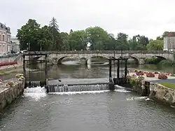 The Sauldre at Romorantin | |
  | |
| Location | |
| Country | France |
| Physical characteristics | |
| Mouth | |
• location | Cher |
• coordinates | 47°16′23″N 1°30′43″E / 47.27306°N 1.51194°E |
| Length | 183.1 km (113.8 mi) |
| Basin size | 2,200 km2 (850 sq mi) |
| Basin features | |
| Progression | Cher→ Loire→ Atlantic Ocean |
| Tributaries | |
| • left | Rère, Petite Sauldre |
| • right | Grande Sauldre |
The Sauldre (French pronunciation: [so(l)dʁ]) is a 183.1 km (113.8 mi) long river in central France, a right tributary of the Cher.[1] Its source is near the village of Montigny, southwest of Sancerre. The Sauldre flows generally northwest, through the following departments and towns:
The Sauldre flows into the Cher near Selles-sur-Cher.
The Rère, Grande Sauldre and Petite Sauldre are among its tributaries.
References
Wikimedia Commons has media related to Sauldre.