Schachendorf
Schachendorf
Cajta | |
|---|---|
.jpg) Schachendorf parish church | |
 Coat of arms | |
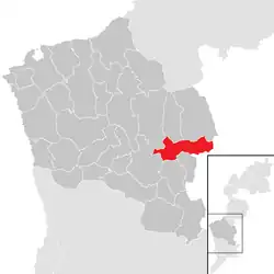 Location within Oberwart district | |
 Schachendorf Location within Austria | |
| Coordinates: 47°16′N 16°26′E / 47.267°N 16.433°E | |
| Country | Austria |
| State | Burgenland |
| District | Oberwart |
| Government | |
| • Mayor | Robert Marlovits (2018) |
| Area | |
• Total | 22.32 km2 (8.62 sq mi) |
| Elevation | 286 m (938 ft) |
| Population (2018-01-01)[2] | |
• Total | 765 |
| • Density | 34/km2 (89/sq mi) |
| Time zone | UTC+1 (CET) |
| • Summer (DST) | UTC+2 (CEST) |
| Postal code | 7472 |
Schachendorf (Croatian: Čajta, Hungarian: Csajta) is a town in the district of Oberwart in Burgenland in southeast Austria. According to the last census, 73% of the population are members of the Burgenland Croat minority, and 5% belong to the Hungarian minority.
Geography
The town lies on the border to Hungary, and there is a road crossing the border from Bucsu to Schachendorf.[3]
Population
|
|
Religion
.jpg)
There are two Catholic parishes and parish churches: St. Martin's (de) and Assumption of Mary's (de).
Culture
In 1974, local Burgenland Croats established folklore ensemble "Stalnost".[4]
References
- ^ "Dauersiedlungsraum der Gemeinden Politischen Bezirke und Bundesländer - Gebietsstand 1.1.2018". Statistics Austria. Retrieved 10 March 2019.
- ^ "Einwohnerzahl 1.1.2018 nach Gemeinden mit Status, Gebietsstand 1.1.2018". Statistics Austria. Retrieved 9 March 2019.
- ^ "International Border Crossing Points on Public Roads Open 24 Hours". Guide Viaggi. Retrieved 2009-01-07.
- ^ Grandić, Tereza (13 July 2024). "Stalnost svečevala 50. obljetnicu" [Stalnost celebrated 50th anniversary]. Hrvatske novine (in Croatian).
External links