Schede (river)
| Schede | |
|---|---|
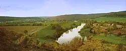 The Weser near Hilwartshausen at its confluence with the Schede (lower left) | |
| Location | |
| Country | Germany |
| State | Lower Saxony |
| District | Göttingen |
| Location | near Hann. Münden |
| Physical characteristics | |
| Source | |
| • location | At the eastern edge of the Bramwald forest near Bühren |
| • coordinates | 51°28′46″N 9°40′03″E / 51.47944°N 9.66750°E |
| • elevation | ca. 300 m above sea level (NHN) |
| Mouth | |
• location | Opposite of Hilwartshausen (a district of Hann. Münden) into the Weser |
• coordinates | 51°26′58″N 9°38′36″E / 51.44944°N 9.64333°E |
• elevation | ca. 110 m above sea level (NHN) |
| Length | 13.2 km (8.2 mi)[1] |
| Basin features | |
| Progression | Weser→ North Sea |
| Tributaries | |
| • left | Thielebach |
Schede is a river of South Lower Saxony, Germany, in the district of Göttingen. It is 13.2-kilometre-long (8.2 mi) right and eastern tributary of the Weser at Hilwartshausen (a district of Hann. Münden).
See also
References