Schulzendorf
Schulzendorf | |
|---|---|
 Coat of arms | |
Location of Schulzendorf within Dahme-Spreewald district 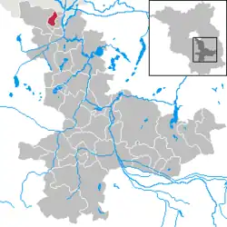 | |
 Schulzendorf  Schulzendorf | |
| Coordinates: 52°22′00″N 13°34′59″E / 52.36667°N 13.58306°E | |
| Country | Germany |
| State | Brandenburg |
| District | Dahme-Spreewald |
| Subdivisions | 4 Ortsteile |
| Government | |
| • Mayor (2017–25) | Markus Mücke[1] (SPD) |
| Area | |
• Total | 9.08 km2 (3.51 sq mi) |
| Elevation | 37 m (121 ft) |
| Population (2023-12-31)[2] | |
• Total | 9,430 |
| • Density | 1,000/km2 (2,700/sq mi) |
| Time zone | UTC+01:00 (CET) |
| • Summer (DST) | UTC+02:00 (CEST) |
| Postal codes | 15732 |
| Dialling codes | 033762 |
| Vehicle registration | LDS |
| Website | www.schulzendorf.de |
ⓘ is a municipality in the district of Dahme-Spreewald in Brandenburg in Germany, located just outside the city limits of Berlin.
Demography
-
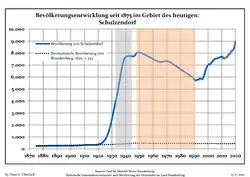 Development of Population since 1875 within the Current Boundaries (Blue Line: Population; Dotted Line: Comparison to Population Development of Brandenburg state; Grey Background: Time of Nazi rule; Red Background: Time of Communist rule)
 -
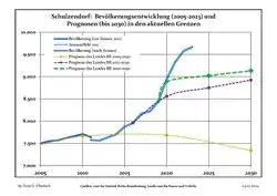 Recent Population Development and Projections (Population Development before Census 2011 (blue line); Recent Population Development according to the Census in Germany in 2011 (blue bordered line); Official projections for 2005-2030 (yellow line); for 2020-2030 (green line); for 2017-2030 (scarlet line)
|
|
|
References
- ^ Landkreis Dahme-Spreewald Wahl der Bürgermeisterin / des Bürgermeisters, accessed 30 June 2021.
- ^ "Bevölkerungsstand im Land Brandenburg Dezember 2023] (Fortgeschriebene amtliche Einwohnerzahlen, basierend auf dem Zensus 2022)". Amt für Statistik Berlin-Brandenburglanguage=German.
- ^ Detailed data sources are to be found in the Wikimedia Commons.Population Projection Brandenburg at Wikimedia Commons