Schwülme
| Schwülme | |
|---|---|
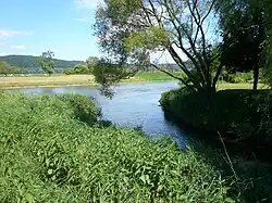 Confluence of the Schwülme and Weser near Lippoldsberg | |
| Location | |
| Country | Germany |
| States | Hesse and Lower Saxony |
| Reference no. | DE: 436 |
| Physical characteristics | |
| Source | |
| • location | West of Hettensen (part of Hardegsen) |
| • coordinates | 51°37′34″N 9°44′57″E / 51.6261556°N 9.7492250°E |
| • elevation | ca. 332 m above sea level (NN) |
| Mouth | |
• location | Near Lippoldsberg into the Weser |
• coordinates | 51°37′39″N 9°33′14″E / 51.627398°N 9.553830°E |
• elevation | ca. 106 m above sea level (NN) |
| Length | 32.0 km (19.9 mi)[1] |
| Basin size | 289.753 km2 (111.874 sq mi)[2] |
| Basin features | |
| Progression | Weser→ North Sea |
The Schwülme is a river of Lower Saxony and Hesse, Germany. It is 29 kilometres (18 mi) long and a right-hand and eastern tributary of the Weser.
See also
References
- ^ Environmental map service of Lower Saxony (Umweltkartendienst des Niedersächsischen Ministeriums für Umwelt, Energie und Klimaschutz)
- ^ Water map service of the Hessian Ministry for the Environment, Energy, Agriculture and Consumer Protection (Hessisches Ministerium für Umwelt, Energie, Landwirtschaft und Verbraucherschutz)