Sennfeld
Sennfeld | |
|---|---|
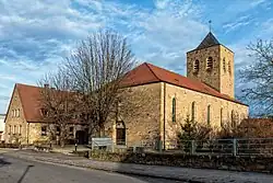 Church of Saint Elisabeth | |
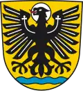 Coat of arms | |
Location of Sennfeld within Schweinfurt district 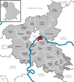 | |
 Sennfeld  Sennfeld | |
| Coordinates: 50°1′N 10°16′E / 50.017°N 10.267°E | |
| Country | Germany |
| State | Bavaria |
| Admin. region | Unterfranken |
| District | Schweinfurt |
| Government | |
| • Mayor (2023–29) | Oliver Schulze[1] (FW) |
| Area | |
• Total | 6.98 km2 (2.69 sq mi) |
| Elevation | 214 m (702 ft) |
| Population (2024-12-31)[2] | |
• Total | 4,212 |
| • Density | 600/km2 (1,600/sq mi) |
| Time zone | UTC+01:00 (CET) |
| • Summer (DST) | UTC+02:00 (CEST) |
| Postal codes | 97526 |
| Dialling codes | 09721 |
| Vehicle registration | SW |
| Website | www.sennfeld.de |
Sennfeld is a municipality in the district of Schweinfurt in Bavaria, Germany. Historically, along with its neighboring village of Gochsheim, it had the rare situation of being a Reichsdorf or Imperial Village.
References
- ^ Liste der ersten Bürgermeister/Oberbürgermeister in kreisangehörigen Gemeinden, Bayerisches Landesamt für Statistik. Retrieved 13 June 2024.
- ^ "Gemeinden, Kreise und Regierungsbezirke in Bayern, Einwohnerzahlen am 31. Dezember 2024; Basis Zensus 2022" [Municipalities, counties, and administrative districts in Bavaria; Based on the 2022 Census] (CSV) (in German). Bayerisches Landesamt für Statistik.