Shagari, Nigeria
Shagari | |
|---|---|
LGA and town | |
 Shagari | |
| Coordinates: 12°38′N 5°0′E / 12.633°N 5.000°E | |
| Country | |
| State | Sokoto State |
| Government | |
| • Districts head | Muhammad Bala Shagari |
| • Local Government Chairman | Barr. Maidawa Kajiji [1] |
| Area | |
• Total | 514 sq mi (1,332 km2) |
| Population (2006) | |
• Total | 156,413 |
| Time zone | UTC+1 (WAT) |
| 3-digit postal code prefix | 851 |
| ISO 3166 code | NG.SO.SH |
Shagari is a Local Government Area in Sokoto State, Nigeria. Its headquarters are in the town of Shagari on the A1 highway. The local government area (LGA) shares a border with Zamfara State in the south.
It has an area of 1,332 km2 and a population of 156,413 at the 2006 census.[2]
The postal code of the area is 851.[3]
Climate
With temperatures ranging from 64°F to 103°F, the climate has two distinct seasons: a scorching, oppressive wet season with mostly cloudy skies, and a scorching, partly cloudy dry season.[4]
Notable People
- Shehu Shagari, the first democratically elected president of Nigeria
References
- ^ "Complete List Of LGAs In Sokoto State And Chairmen". Retrieved 2025-01-29.
- ^ HASC, population, area and Headquarters Statoids
- ^ "Post Offices- with map of LGA". NIPOST. Archived from the original on 2012-11-26. Retrieved 2009-10-20.
- ^ "Shagari Climate, Weather By Month, Average Temperature (Nigeria) - Weather Spark". weatherspark.com. Retrieved 2023-09-01.
State capital: Sokoto | ||
| Local government areas | 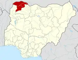 | |